
Make a donation
Nagaland topographic map
Click on the map to display elevation.
Make a donation
Nagaland
Nagaland lies between 93°20'E and 95°15'E longitude and between 25°6'N and 27°4'N latitude. It is largely a mountainous state. The Naga Hills rise from the Brahmaputra Valley in Assam to about 610 metres (2,000 ft) and rise further to the southeast, as high as 1,800 metres (6,000 ft). Mount Saramati at an elevation of 3,841 metres (12,602 ft) is the state's highest peak; this is where the Naga Hills merge with the Patkai Range in which form the boundary with Burma. Rivers such as the Doyang and Diphu to the north, the Barak river in the southwest, dissect the entire state.
Make a donation
About this map
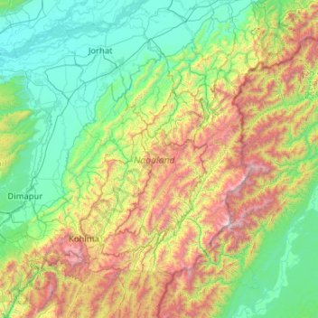
Name: Nagaland topographic map, elevation, terrain.
Location: Nagaland, India (25.19870 93.32670 27.03580 95.24238)
Average elevation: 824 m
Minimum elevation: 67 m
Maximum elevation: 3,721 m
Make a donation
Other topographic maps
Click on a map to view its topography, its elevation and its terrain.
Bhubaneshwar
India > Odisha > Bhubaneswar (M.Corp.)
Bhubaneswar is in Khordha district of Odisha. It is in the eastern coastal plains, along the axis of the Eastern Ghats mountains. The city has an average altitude of 45 m (148 ft) above sea level. It lies southwest of the Mahanadi River that forms the northern boundary of Bhubaneswar metropolitan area, within…
Average elevation: 30 m
Thiruvananthapuram
India > Kerala > Thiruvananthapuram
Thiruvananthapuram is built on seven hills by the seashore and is at 8°30′N 76°54′E / 8.5°N 76.9°E / 8.5; 76.9 on the west coast, near the southern tip of mainland India. The city is on the west coast of India and is bounded by the Laccadive Sea to its west and the Western Ghats to its east.…
Average elevation: 33 m
Make a donation
Maharashtra
Maharashtra is the third largest state by area in India. The Western Ghats better known as Sahyadri, are a hilly range running parallel to the coast, at an average elevation of 1,200 metres (4,000 ft). Kalsubai, a peak in the Sahyadris, near Nashik city is the highest elevated point in Maharashtra. To the west…
Average elevation: 478 m
Mumbai
Mumbai lies at the mouth of the Ulhas River on the western coast of India, in the coastal region known as the Konkan. It sits on Salsette Island (Sashti Island), which it partially shares with the Thane district. Mumbai is bounded by the Arabian Sea to the west. Many parts of the city lie just above sea level,…
Average elevation: 13 m
Make a donation
Guwahati
Professor Abani Kumar Bhagawati of Gauhati University stated that since before there were sufficient wetlands to absorb rainwater and channels to carry excess water to the Brahmaputra, the city did not experience floods. However, human interference has disrupted the natural topography, leading to the current…
Average elevation: 113 m
Make a donation
Surat
India > Gujarat > Katargam Taluka > Surat
Surat is a port city situated on the banks of the Tapi river. Damming of the Tapi caused the original port facilities to close; the nearest port is now in the Magadalla and Hazira area of Surat Metropolitan Region.It has famous beach called 'Dumas Beach' located in Hazira. The city is located at 21°10′N…
Average elevation: 11 m
Leh
Leh (/ˈlɛ/) (Ladakhi: གླེ) is the joint capital and largest city of Ladakh, a union territory of India. Leh, located in the Leh district, was also the historical capital of the Kingdom of Ladakh, the seat of which was in the Leh Palace, the former residence of the royal family of Ladakh, built in the…
Average elevation: 4,294 m
Make a donation
Mysuru
India > Karnataka > Mysuru taluk
Mysore (/maɪˈsɔːr/ (listen)), officially Mysuru ([ˈmaɪˈsuːɾu] (listen)), is a city in the southern part of the state of Karnataka, India. Mysore city is geographically located between 12° 18′ 26″ north latitude and 76° 38′ 59″ east longitude. It is located at an altitude of 770 m (2,530 ft)…
Average elevation: 727 m
Kalaburagi
India > Karnataka > Kalaburagi taluku
The entire district is on the Deccan Plateau, and the elevation ranges from 300 to 750 m above MSL. Two main rivers, the Krishna and Bhima, flow through the district. The predominant soil type is black soil. The district has many tanks, which irrigate the land along with the river. The Upper Krishna Project is…
Average elevation: 465 m
Vagamon
Vagamon, due to its elevation and climate, has a unique ecosystem, leading to the emergence of rich natural vegetation, plant species, shola forests etc. From the early 20th century plantation crops like tea, coffee started. Vagamon hills are home to less explored flora and fauna. A faunal diversity study…
Average elevation: 866 m
Make a donation
Dehradun
India > Uttarakhand > Dehradun
The city of Dehradun mainly lies in Doon Valley and is at a varying height from 410 m (1,350 ft) in Clement Town to above 700 m (2,300 ft) at Malsi which is 15 km (9.3 mi) from the city. However, the average elevation is 450 m (1,480 ft) above sea level. Malsi is the starting point of Lesser Himalayan Range…
Average elevation: 904 m
Rupnagar
India > Punjab > Rupnagar Tahsil
Rupnagar is located at 30°58′N 76°32′E / 30.97°N 76.53°E / 30.97; 76.53. It has an average elevation of 260 metres (850 ft). The town lies on the bank of Satluj River and the Shivalik hill range spreads along the opposite bank of the river.
Average elevation: 281 m
Make a donation
Make a donation
Mussoorie
India > Uttarakhand > Dehradun
Mussoorie is at an average altitude of 2,005 metres (6,578 ft). To the northeast are the Himalayan snow ranges, and to the south, the Doon Valley and Shiwalik ranges. The second highest point is the original Lal Tibba in Landour, with a height of over 2,275 m (7,464 ft). Mussoorie is popularly known as The…
Average elevation: 1,594 m
Make a donation
Dharamshala
India > Himachal Pradesh > Dharamshala
Dharamshala has an average elevation of 1,457 m (4,780 ft), covering an area of almost 8.51 km2 (3.29 sq mi). Dharamsala is located in the Kangra Valley, in the shadow of the Dhauladhar mountains.
Average elevation: 1,781 m
Make a donation
Lucknow
India > Uttar Pradesh > Lucknow
Lucknow stands at an elevation of approximately 123 metres (404 ft) above sea level. The city had an area of 402 km2 (155 square miles) until December 2019, when 88 villages were added to the municipal limits and the area increased to 631 km2 (244 square miles). Bounded on the east by Barabanki, on the west by…
Average elevation: 120 m
Make a donation
Salem
Salem is located at 11°40′N 78°08′E / 11.67°N 78.14°E / 11.67; 78.14, at an average elevation of 278 m (912 ft). The city is surrounded by hills: Nagaramalai on the north, Jarugumalai on the south, Kanjamalai on the west, Godumalai on the east and the Shevaroy Hills on the northeast.…
Average elevation: 418 m
Make a donation
Make a donation
Make a donation
Make a donation
Make a donation
Make a donation
Srinagar
India > Jammu and Kashmir > Srinagar (South)
Under the Köppen climate classification, Srinagar has a four-season humid subtropical climate (Cfa) with hot summers and cool winters. The valley is surrounded by the Himalayas on all sides. Due to influence from Himalayan rain shadow and western disturbances, Srinagar has year-round precipitation; the spring…
Average elevation: 1,805 m
Make a donation
Siliguri
India > West Bengal > Matigara block
Siliguri located at the foothills of the eastern Himalayas at a location of 26°43′N 88°26′E / 26.71°N 88.43°E / 26.71; 88.43. This city is spread over an area of 260 km2 within the Siliguri Corridor, also known as the Chicken's neck. The city is surrounded by dense forests towards north and…
Average elevation: 121 m
Make a donation
Guntakal
India > Andhra Pradesh > Guntakal
Guntakal is located at 15°10′N 77°23′E / 15.17°N 77.38°E / 15.17; 77.38. It has an average elevation of 432 metres (1,417 ft).
Average elevation: 445 m
Make a donation
Make a donation
Baramulla
India > Jammu and Kashmir > Baramulla
Baramulla is located at 34.2° N 74.34° E. It has an average elevation of 1,593 meters (5,226 feet).
Average elevation: 1,969 m
Make a donation
Make a donation
Sanduru
India > Karnataka > Sanduru taluk
Sanduru is located at 15°06′N 76°33′E / 15.1°N 76.55°E / 15.1; 76.55. It has an average elevation of 565 metres (1853 feet).
Average elevation: 647 m
Make a donation
Make a donation
Chennai
Chennai is located on the south–eastern coast of India in the north–eastern part of Tamil Nadu on a flat coastal plain known as the Eastern Coastal Plains. Its average elevation is around 6.7 metres (22 ft), and its highest point is 60 m (200 ft). Chennai is 2,184 kilometres (1,357 mi) south of Delhi,…
Average elevation: 7 m
Make a donation