
Leimakhong topographic map
Interactive map
Click on the map to display elevation.
About this map
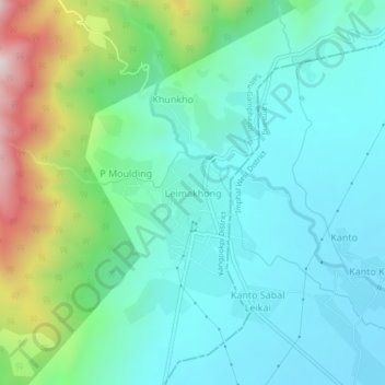
Name: Leimakhong topographic map, elevation, terrain.
Average elevation: 967 m
Minimum elevation: 811 m
Maximum elevation: 1,464 m
Other topographic maps
Click on a map to view its topography, its elevation and its terrain.
Koubru
India > Manipur > Saitu-Gamphazol
Koubru, Saitu-Gamphazol, Kangpokpi, Manipur, India
Average elevation: 2,146 m