
Make a donation
Gotteszell topographic map
Click on the map to display elevation.
Make a donation
About this map
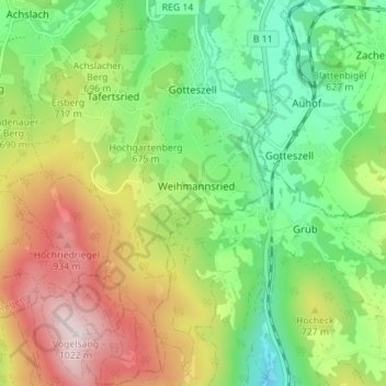
Name: Gotteszell topographic map, elevation, terrain.
Average elevation: 675 m
Minimum elevation: 460 m
Maximum elevation: 1,002 m
Make a donation
Other topographic maps
Click on a map to view its topography, its elevation and its terrain.
Silberberg
Deutschland > Bayern > Landkreis Regen > Bodenmais
Der Silberberg ist ein 955 m ü. NHN hoher Berg, der sich unmittelbar östlich über der Ortschaft Bodenmais im Bayerischen Wald erhebt. Seine Höhe ist zwar bescheiden, durch den felsigen Doppelgipfel gehört er dennoch zu den markantesten Bergen der Umgebung und bietet dadurch einen weiten Ausblick.
Average elevation: 781 m
Großer Arber
Deutschland > Bayern > Landkreis Regen > Bayerisch Eisenstein
Der Große Arber (tschechisch Velký Javor) ist mit 1455,5 m ü. NHN der höchste Berg des Böhmerwaldes / Bayerischen Waldes und von Niederbayern. Er ist zudem der höchste Berg Bayerns außerhalb der Alpen und nach dem Feldberg der zweithöchste Berg Deutschlands außerhalb der Alpen. Außerdem stellt ein…
Average elevation: 1,141 m
Make a donation
Make a donation
Make a donation
Make a donation
Make a donation
Make a donation
Reinhartsmais
Deutschland > Bayern > Landkreis Regen > Regen
Aden | Augrub | Bärndorf | Bettmannsäge | Dreieck | Ebenhof | Ecklend | Edhof | Eggenried | Finkenried | Frauenmühle | Großseiboldsried | Huberhof | Kagerhof | Kattersdorf | Kerschlhöh | Kleinseiboldsried | Kreuzerhof | Kühhof | March | Maschenberg | Matzelsried | Metten | Neigerhöhe | Neigermühle |…
Average elevation: 604 m
Make a donation
Make a donation
Make a donation
Make a donation
Make a donation
Make a donation
Großer Arbersee
Deutschland > Bayern > Landkreis Regen > Bayerisch Eisenstein
Average elevation: 1,066 m
Make a donation
Schwalstein
Deutschland > Bayern > Landkreis Regen > Viechtach > Fischaitnach
Average elevation: 486 m
Make a donation
Teufelstisch
Deutschland > Bayern > Landkreis Regen > Bischofsmais
Der Teufelstisch (901 m) ist eine sagenumwobene Felsformation in der Nähe von Bischofsmais im mittleren Bayerischen Wald und ein stark frequentiertes Wanderziel. Er bildet einen eigenen kleinen Höhenzug mit beachtlichen Felsen entlang der Grathöhe.
Average elevation: 766 m
Make a donation
Make a donation
Einödriegel
Deutschland > Bayern > Landkreis Regen > Bischofsmais
Benachbarte Berge sind der Geißkopf, der Dreitannenriegel und der Breitenauriegel, die alle im selben Höhenzug nahe Bischofsmais liegen. Auf dem Einödriegel mit schöner Aussicht nach Westen und Nordosten steht ein stattliches Gipfelkreuz mit Rastbänken. Im Winter führt ein Skilift von der Unterbreitenau…
Average elevation: 915 m
Make a donation
Großer Riedelstein
Deutschland > Bayern > Landkreis Regen > Arnbruck
Der Große Riedelstein bildet mit seiner Höhe von 1132,9 m ü. NHN den höchsten Punkt des Kaitersberges im Bayerischen Wald. Seinen felsigen Gipfel schmückt das steinerne Denkmal zu Ehren des Dichters Maximilian Schmidt, genannt Waldschmidt.
Average elevation: 839 m
Make a donation
Make a donation
Make a donation
Make a donation