
Bärndorf topographic map
Interactive map
Click on the map to display elevation.
About this map
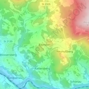
Name: Bärndorf topographic map, elevation, terrain.
Average elevation: 569 m
Minimum elevation: 405 m
Maximum elevation: 896 m
Other topographic maps
Click on a map to view its topography, its elevation and its terrain.
Blossersberg
Deutschland > Bayern > Landkreis Regen > Viechtach
Blossersberg, Viechtach, Landkreis Regen, Bayern, 94234, Deutschland
Average elevation: 484 m
Eben
Deutschland > Bayern > Landkreis Regen > Viechtach > Pirka
Eben, Pirka, Viechtach, Landkreis Regen, Bayern, 94234, Deutschland
Average elevation: 565 m