Geolocate

Borj El Amri topographic map

Interactive map

Click on the map to display elevation.

About this map

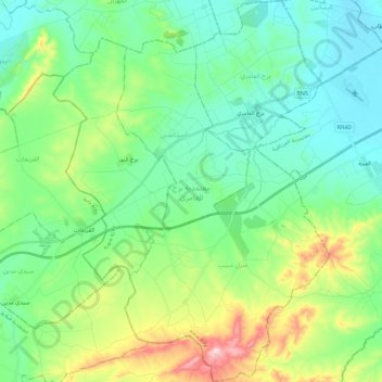
Name: Borj El Amri topographic map, elevation, terrain.

Location: Borj El Amri, La Manouba, Tunisie (36.58736 9.76849 36.76505 9.92874)

Average elevation: 113 m

Minimum elevation: 26 m

Maximum elevation: 362 m

Other topographic maps

Click on a map to view its topography, its elevation and its terrain.

Mornaguia

Tunisie > La Manouba

Mornaguia, La Manouba, Tunisie

Average elevation: 88 m

Medjerda

Tunisie > La Manouba

Medjerda, Borj Ettoumi, El Battane, La Manouba, Tunisie

Average elevation: 47 m

Manouba‬‬

Tunisie > La Manouba

Manouba‬‬, La Manouba, Tunisie

Average elevation: 48 m

Douar Hicher

Tunisie > La Manouba

Douar Hicher, La Manouba, Tunisie

Average elevation: 78 m

Tebourba

Tunisie > La Manouba

Tebourba, La Manouba, 1130, Tunisie

Average elevation: 135 m

Oued Ellil

Tunisie > La Manouba

Oued Ellil, La Manouba, 2021, Tunisie

Average elevation: 72 m