
Oued Ellil topographic map
Interactive map
Click on the map to display elevation.
About this map
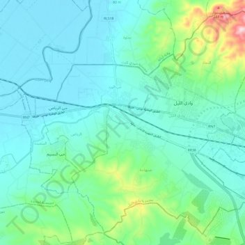
Name: Oued Ellil topographic map, elevation, terrain.
Location: Oued Ellil, La Manouba, 2021, Tunisie (36.78665 9.96423 36.87287 10.08242)
Average elevation: 72 m
Minimum elevation: 13 m
Maximum elevation: 324 m
Other topographic maps
Click on a map to view its topography, its elevation and its terrain.