Geolocate

Community of Madrid topographic map

Interactive map

Click on the map to display elevation.

Community of Madrid

Most of province lies between 600 and 1,000 m above sea level. However, there the altitude ranges from the 2,428 metres of Peñalara and the 430 metres of the Alberche river when it leaves Villa del Prado into the province of Toledo. Other considerable heights, as well as being famous, are the Bola del Mundo ("Ball of the World") in Navacerrada, at a height of 2,258 m, the Siete Picos ("Seven Peaks") in Cercedilla, at 2,138 m, and the Peña Cebollera (2,129 m) at the northernmost end of the province, a tripoint between the Madrid region and the provinces of Segovia and Guadalajara.

Wikipedia (CC-BY-SA 3.0)

About this map

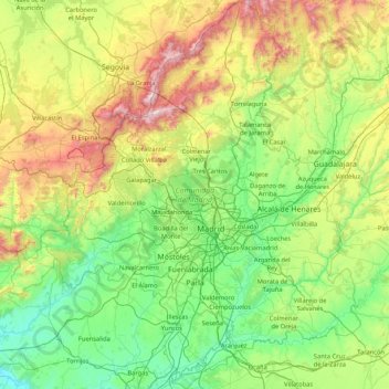
Name: Community of Madrid topographic map, elevation, terrain.

Location: Community of Madrid, Spain (39.88463 -4.57901 41.16574 -3.05299)

Average elevation: 852 m

Minimum elevation: 385 m

Maximum elevation: 2,404 m

Other topographic maps

Click on a map to view its topography, its elevation and its terrain.

La Rozadieḷḷa

Spain > Asturias > Lena

Average elevation: 470 m

Lires

Spain > Galicia > Fisterra > Cee

Average elevation: 63 m

Llesp

Spain > Catalonia > Alta Ribagorça > el Pont de Suert

Average elevation: 1,253 m

Lecina

Spain > Aragon > Sobrarbe > Bárcabo

Average elevation: 805 m

El Pueyo de Jaca

Spain > Aragon > Alto Gállego > Panticosa

Average elevation: 1,314 m

Undués Pintano

Spain > Aragon > Cinco Villas > Los Pintanos

Average elevation: 712 m

Ekai

Spain > Navarre > Sakana > Arakil

Average elevation: 563 m

Cardet

Spain > Catalonia > Alta Ribagorça > la Vall de Boí > Barruera

Average elevation: 1,525 m

Vall de Boí

Spain > Catalonia > Alta Ribagorça > la Vall de Boí

Average elevation: 1,812 m

Via verde

Spain > Andalusia > Jaén > Urbanización Virgen Blanca

Average elevation: 527 m

Casas de Mindaño

Spain > Extremadura > Tornavacas

Average elevation: 1,310 m

Aneto

Spain > Aragon > La Ribagorza > Benasque/Benás

Average elevation: 2,925 m

La Jalva

Spain > Castile and León > Encinas de Abajo

Average elevation: 818 m

Vallejo

Spain > Cantabria > Silió

Average elevation: 347 m

Saviñao

Spain > Galicia > Meira > Pol

Average elevation: 580 m

Barallobre

Spain > Galicia > Ferrol > Fene

Average elevation: 50 m

Castillo de Peñiscola

Spain > Valencian Community > Castelló / Castellón > Peníscola / Peñíscola

The castle is situated on a crag overlooking the Mediterranean Sea, at an altitude of 64 metres (210 ft) above mean sea level.

Average elevation: 5 m

El Raso

Spain > Castile and León > Arenas de San Pedro

Average elevation: 1,770 m

Nigrán

Spain > Galicia > Vigo

Average elevation: 73 m

Los Dragos

Spain > Moya

Average elevation: 231 m

Montecillo

Spain > Community of Madrid > Villaconejos

Average elevation: 677 m

Herrán

Spain > Cantabria > Costa Occidental > Santillana del Mar

Average elevation: 109 m

Campo Asia

Spain > Andalusia > Costa del Sol Occidental > Mijas

Average elevation: 108 m

Martín Moro

Spain > Andalusia > Morón de la Frontera

Average elevation: 263 m

Córdoba

Spain > Andalusia > Córdoba

Average elevation: 262 m

Menorca

Spain > Balearic Islands > Menorca > es Migjorn Gran

Average elevation: 9 m

Etxeberri

Spain > Navarre > Sakana > Arakil

Average elevation: 573 m

Almeria

Spain > Andalusia > Almeria

Average elevation: 250 m

Lezea

Spain > Navarre > Imotz

Average elevation: 603 m

El Rosario

Spain > Canary Islands > Vilaflor

Average elevation: 2,045 m

La Ensillada

Spain > Canary Islands > Arona

Average elevation: 115 m

Uribe

Spain > Basque Country > Uribe

Average elevation: 353 m

Coria

Spain > Extremadura > Coria

Average elevation: 256 m

El Róquez

Spain > Andalusia > Chirivel

Average elevation: 1,124 m

Cerro de la Estrella

Spain > Castile and León > Cebreros

Average elevation: 1,006 m

El Roque

Spain > Canary Islands > Adeje

Average elevation: 904 m

León

Spain > Castile and León > León

Average elevation: 838 m

Limiñón

Spain > Galicia > Rombo

Average elevation: 101 m

Gomia

Spain > Castile and León > Las Quintanillas

Average elevation: 847 m

A Coruña

Spain > Galicia > A Coruña > A Coruña

Average elevation: 68 m

Tejeda

Spain > Castile and León > Tejeda y Segoyuela > Tejeda

Average elevation: 941 m

Linares

Spain > Cantabria > Castro-Urdiales

Average elevation: 416 m

La Jabera

Spain > Castile and León > Villar de Fallaves

Average elevation: 704 m

Iribarren

Spain > Navarre > Juslapeña

Average elevation: 532 m

Beas

Spain > Andalusia > Beas > Beas

Average elevation: 114 m

Cádiz

Spain > Andalusia > Cádiz

The Baluarte de la Candelaria (fortress or stronghold of Candlemas) is a military fortification. Taking advantage of a natural elevation of land, it was constructed in 1672 at the initiative of the governor, Diego Caballero de Illescas. Protected by a seaward-facing wall that had previously served as a…

Average elevation: 3 m

La Comilla

Spain > Castile and León > Aldealafuente

Average elevation: 993 m

Guama

Spain > Santiago del Teide

Average elevation: 569 m

Parapa

Spain > Castile and León > Briviesca

Average elevation: 730 m

Las Vega

Spain > Castile-La Mancha > Torrijos > Camarena

Average elevation: 596 m

Vigo

Spain > Galicia > Vigo > Vigo

Vigo has a warm-summer Mediterranean climate "Csb" according to the Köppen climate classification. Although Vigo is the rainiest city in Galicia, nowadays, with its noticeable drying trend in the summer, Vigo's climate is more similar to the variant of the oceanic climate commonly seen in the Pacific…

Average elevation: 121 m

Gijón / Xixón

Spain > Asturias > Gijón / Xixón

Average elevation: 107 m

Murcia

Spain > Region of Murcia > Área Metropolitana de Murcia > Murcia

Murcia is located near the center of a low-lying fertile plain known as the huerta (orchard or vineyard) of Murcia. The Segura River and its right-hand tributary, the Guadalentín, run through the area. The city has an elevation of 43 metres (141 ft) above sea level and its municipality covers approximately…

Average elevation: 169 m

Toroño

Spain > Castile and León > Porto

Average elevation: 1,495 m