
Make a donation
Ballyclogh (South) topographic map
Click on the map to display elevation.
Make a donation
About this map
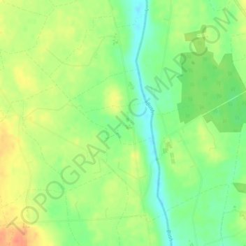
Name: Ballyclogh (South) topographic map, elevation, terrain.
Location: Ballyclogh (South), Northern Ireland, United Kingdom (55.16403 -6.53676 55.16873 -6.52320)
Average elevation: 45 m
Minimum elevation: 23 m
Maximum elevation: 67 m
Make a donation
Other topographic maps
Click on a map to view its topography, its elevation and its terrain.
Make a donation
Make a donation
Make a donation
Make a donation
Make a donation
Make a donation
Make a donation
Dunseverick Castle
United Kingdom > Northern Ireland > County Antrim > Dunseverick
Average elevation: 29 m
Make a donation
Make a donation
Make a donation
Make a donation
Make a donation
Newtownstewart
United Kingdom > Northern Ireland > County Tyrone > Newtownstewart
Average elevation: 87 m
Make a donation
Ballyquinton Point nature reserve
United Kingdom > Northern Ireland > County Down
Average elevation: 2 m
Make a donation
Old Mill
United Kingdom > Northern Ireland > County Antrim > Ballygally > Old Mill
Average elevation: 47 m
Make a donation
Mountsandel
United Kingdom > Northern Ireland > County Londonderry > Coleraine
Average elevation: 25 m
Dungannon Fort
United Kingdom > Northern Ireland > County Londonderry > Castlerock > Downhill
Average elevation: 60 m
Jonesborough
United Kingdom > Northern Ireland > County Armagh > Jonesborough
Average elevation: 130 m
Make a donation
Make a donation
Make a donation
Make a donation
Make a donation