
Thank you for supporting this site ❤️
Make a donation
Make a donation
Ringsend topographic map
Click on the map to display elevation.
Thank you for supporting this site ❤️
Make a donation
Make a donation
About this map
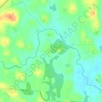
Name: Ringsend topographic map, elevation, terrain.
Average elevation: 44 m
Minimum elevation: 29 m
Maximum elevation: 70 m
Thank you for supporting this site ❤️
Make a donation
Make a donation
Other topographic maps
Click on a map to view its topography, its elevation and its terrain.
Mountsandel
United Kingdom > Northern Ireland > County Londonderry > Coleraine
Average elevation: 25 m