
Thank you for supporting this site ❤️
Make a donation
Make a donation
Split-Dalmatia County topographic map
Click on the map to display elevation.
Thank you for supporting this site ❤️
Make a donation
Make a donation
About this map
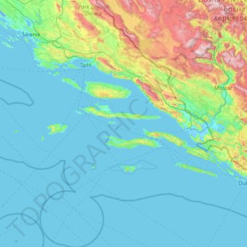
Name: Split-Dalmatia County topographic map, elevation, terrain.
Location: Split-Dalmatia County, Croatia (42.17660 15.18586 43.97399 17.45085)
Average elevation: 255 m
Minimum elevation: -5 m
Maximum elevation: 2,177 m
Thank you for supporting this site ❤️
Make a donation
Make a donation
Other topographic maps
Click on a map to view its topography, its elevation and its terrain.
Thank you for supporting this site ❤️
Make a donation
Make a donation
Thank you for supporting this site ❤️
Make a donation
Make a donation
Zagreb
Croatia > City of Zagreb > Zagreb
Zagreb (/ˈzɑːɡrɛb, ˈzæɡrɛb, zɑːˈɡrɛb/ ZAH-greb, ZAG-reb, zah-GREB, Croatian: (listen)) is the capital and largest city of Croatia. It is in the northwest of the country, along the Sava river, at the southern slopes of the Medvednica mountain. Zagreb lies at an elevation of approximately 122 m…
Average elevation: 193 m
Thank you for supporting this site ❤️
Make a donation
Make a donation