Nelson County topographic map
Interactive map
Click on the map to display elevation.
About this map
![Nelson County topographic map, elevation, terrain](/pub/maps/relation/lrgp/m5zq1h/thumbnail.jpg)
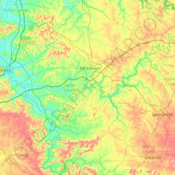
Name: Nelson County topographic map, elevation, terrain.
Location: Nelson County, Kentucky, United States (37.52277 -85.74251 37.99056 -85.15064)
Average elevation: 207 m
Minimum elevation: 127 m
Maximum elevation: 352 m
Other topographic maps
Click on a map to view its topography, its elevation and its terrain.
![Girkin topographic map, elevation, terrain](/pub/maps/node/ttj/3k4h3dn/icon.jpg)
Girkin
United States > Kentucky > Warren County
Girkin, Warren County, Kentucky, United States
Average elevation: 181 m
![Monticello topographic map, elevation, terrain](/pub/maps/relation/34s/wqvt6/icon.jpg)
Monticello
United States > Kentucky > Wayne County
Monticello, Wayne County, Kentucky, 42633, United States
Average elevation: 304 m
![Springfield topographic map, elevation, terrain](/pub/maps/relation/h14/36ggp/icon.jpg)
Springfield
United States > Kentucky > Washington County
Springfield, Washington County, Kentucky, United States
Average elevation: 243 m
![Menifee County topographic map, elevation, terrain](/pub/maps/relation/45m2/4bqjgp/icon.jpg)
Menifee County
Menifee County, Kentucky, United States
Average elevation: 313 m
![Bowling Green topographic map, elevation, terrain](/pub/maps/relation/v14/36kgp/icon.jpg)
Bowling Green
United States > Kentucky > Warren County
Bowling Green, Warren County, Kentucky, 42101, United States
Average elevation: 169 m
![Briartown topographic map, elevation, terrain](/pub/maps/node/r7tj/hl5kcrr/icon.jpg)
Briartown
United States > Kentucky > Washington County > Springfield
Briartown, Springfield, Washington County, Kentucky, 40069, United States
Average elevation: 233 m
![Barrel Lake topographic map, elevation, terrain](/pub/maps/way/kw4s/z3mmj5k/icon.jpg)
Barrel Lake
United States > Kentucky > Kenton County
Barrel Lake, Kenton County, Kentucky, United States
Average elevation: 266 m
![Edmonson County topographic map, elevation, terrain](/pub/maps/relation/7118/17xkrr/icon.jpg)
Edmonson County
Edmonson County, Kentucky, United States
Average elevation: 196 m
![Forks of Elkhorn topographic map, elevation, terrain](/pub/maps/node/7jz4/m6zbq51/icon.jpg)
Forks of Elkhorn
United States > Kentucky > Franklin County
Forks of Elkhorn, Franklin County, Kentucky, United States
Average elevation: 224 m
![Three Springs topographic map, elevation, terrain](/pub/maps/node/gjtf/jvqxc5k/icon.jpg)
Three Springs
United States > Kentucky > Warren County
Three Springs, Warren County, Kentucky, 42102, United States
Average elevation: 174 m
![Crestwood topographic map, elevation, terrain](/pub/maps/relation/r3l/95ktf/icon.jpg)
Crestwood
United States > Kentucky > Oldham County
Crestwood, Oldham County, Kentucky, United States
Average elevation: 223 m
![Cynthiana topographic map, elevation, terrain](/pub/maps/relation/1f3/7g94s/icon.jpg)
Cynthiana
United States > Kentucky > Harrison County
Cynthiana, Harrison County, Kentucky, 41031, United States
Average elevation: 238 m
![Gibralter topographic map, elevation, terrain](/pub/maps/node/lx51/qg4hm9m/icon.jpg)
Gibralter
United States > Kentucky > Crittenden County
Gibralter, Crittenden County, Kentucky, United States
Average elevation: 136 m
![Franklin County topographic map, elevation, terrain](/pub/maps/relation/fcnh/d2n1kl/icon.jpg)
Franklin County
United States > Kentucky > Franklin County
Franklin County, Kentucky, 40601, United States
Average elevation: 235 m
![Louisville topographic map, elevation, terrain](/pub/maps/node/jvtf/l929tgp/icon.jpg)
Louisville
United States > Kentucky > Jefferson County > Louisville
Louisville, Jefferson County, Kentucky, 40202-2923, United States
Average elevation: 180 m
![Lexington topographic map, elevation, terrain](/pub/maps/node/b14/kq65gf3/icon.jpg)
Lexington
United States > Kentucky > Lexington
Lexington, Fayette County, Kentucky, 40508, United States
Average elevation: 285 m