
Make a donation
Enfield topographic map
Click on the map to display elevation.
Make a donation
About this map
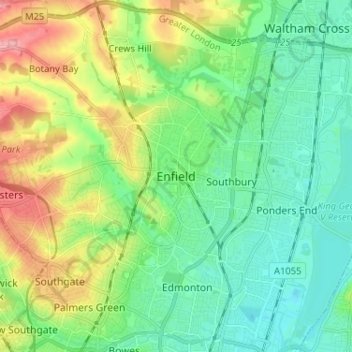
Name: Enfield topographic map, elevation, terrain.
Location: Enfield, Greater London, England, EN2 6LD, United Kingdom (51.61209 -0.12102 51.69209 -0.04102)
Average elevation: 39 m
Minimum elevation: 7 m
Maximum elevation: 107 m
Make a donation
Other topographic maps
Click on a map to view its topography, its elevation and its terrain.
Make a donation
Make a donation
Portsmouth
Portsmouth is 73.5 miles (118.3 km) by road from central London, 49.5 miles (79.7 km) west of Brighton, and 22.3 miles (35.9 km) east of Southampton. It is located primarily on Portsea Island and is the United Kingdom's only island city, although the city has expanded to the mainland. Gosport is a town and…
Average elevation: 7 m
Make a donation
Make a donation
Make a donation
Make a donation
Make a donation
Stratford-upon-Avon
United Kingdom > England > Warwickshire > Stratford-on-Avon
Average elevation: 61 m
Upper Strinesdale Reservoir
United Kingdom > England > Oldham > Scouthead > Top O' Th' Meadows
Average elevation: 276 m
Moretonhampstead
United Kingdom > England > Devon > Teignbridge > Moretonhampstead
Average elevation: 237 m
Make a donation
Make a donation
Make a donation
Berkshire
United Kingdom > England > West Berkshire
All of the county is drained by the Thames. Berkshire divides into two topological (and associated geological) sections: east and west of Reading. North-east Berkshire has the low calciferous (limestone) m-shaped bends of the Thames south of which is a broader, clayey, gravelly former watery plain or belt from…
Average elevation: 100 m
Make a donation
Make a donation
Make a donation
Epping Forest
United Kingdom > England > Essex > Epping Forest
It lies on a ridge between the valleys of the rivers Lea and Roding. It contains areas of woodland, grassland, heath, streams, bogs and ponds, and its elevation and thin gravelly soil (the result of glaciation) historically made it less suitable for agriculture. The forest was historically managed as a common;…
Average elevation: 44 m
Make a donation
Berwick-upon-Tweed
United Kingdom > England > Northumberland
In the 1840s, Samuel Lewis included similar entries for Berwick-upon-Tweed in both his England and Scotland Topographical Dictionary. Berwick remained a county in its own right, and remained a separate parliamentary constituency until 1885 when it was merged to become a division of Northumberland under the…
Average elevation: 33 m
Make a donation
Make a donation
White Cliffs of Dover
United Kingdom > England > Kent > Dover > St. Margaret's at Cliffe
Average elevation: 49 m
Make a donation
Toddygill Plantation
United Kingdom > England > Westmorland and Furness > Warcop
Average elevation: 172 m
Make a donation
Make a donation
Bury St Edmunds
United Kingdom > England > Suffolk > West Suffolk
The name Bury is etymologically connected with borough, which has cognates in other Germanic languages such as German Burg 'fortress, castle' and Bereich '(defined) area' Old Norse borg 'wall, castle'; and Gothic baurg 'city'. They all derive from Proto-Germanic *burgs 'fortress'. This in turn derives from the…
Average elevation: 54 m
Make a donation
Knole Park (Deer Park)
United Kingdom > England > Kent > Sevenoaks > Sevenoaks Weald
Average elevation: 161 m
Make a donation
Hathersage
United Kingdom > England > Derbyshire > Derbyshire Dales
The Fat Boys Stanage Struggle is a popular local fell race that starts in Hathersage, altitude 91 metres (299 ft), and routes up to and along Stanage Edge to High Neb, 458 metres (1,503 ft), before returning to the village 367 metres (1,204 ft) below.
Average elevation: 311 m
Make a donation
Make a donation
Fawfieldhead
United Kingdom > England > Staffordshire > Staffordshire Moorlands
Average elevation: 311 m
Make a donation
Catworth
United Kingdom > England > Cambridgeshire > Huntingdonshire > Catworth
Average elevation: 54 m
Penistone
United Kingdom > England > Thurlstone
Penistone has a thriving market, although smaller since the building of a Tesco supermarket in 2011, which reduced the market footprint. The cattle market, which was the centre of the farming livestock trade, and the Fur n Feathers market, have long since gone. At 747 feet (228 metres) elevation, Penistone is…
Average elevation: 229 m
Make a donation