
Bandundu topographic map
Interactive map
Click on the map to display elevation.
About this map
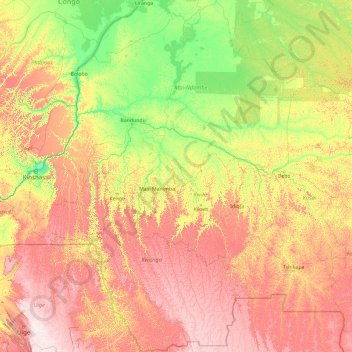
Name: Bandundu topographic map, elevation, terrain.
Location: Bandundu, Democratic Republic of the Congo (-8.13104 15.89472 -0.69543 21.00530)
Average elevation: 555 m
Minimum elevation: 256 m
Maximum elevation: 1,325 m
Other topographic maps
Click on a map to view its topography, its elevation and its terrain.
Mbanza-Makuta
Democratic Republic of the Congo > Kongo Central > Mbanza-Ngungu
Average elevation: 483 m
Mount Stanely
Democratic Republic of the Congo > North Kivu
Mount Stanley or Mount Ngaliema (/əŋɡɑːˈljeɪmə/, also US: /-mɑː/, UK: /əŋˌɡɑːliˈeɪmə/) is a mountain located in the Rwenzori Mountains. With an elevation of 5,109 m (16,763 ft), it is the highest mountain of both the Democratic Republic of the Congo and Uganda, and the third highest in…
Average elevation: 4,141 m