
Pweto topographic map
Interactive map
Click on the map to display elevation.
About this map
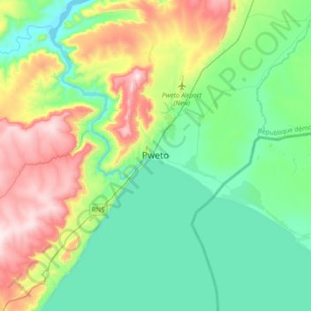
Name: Pweto topographic map, elevation, terrain.
Location: Pweto, Haut-Katanga, Democratic Republic of the Congo (-8.63411 28.73871 -8.31411 29.05871)
Average elevation: 1,051 m
Minimum elevation: 876 m
Maximum elevation: 1,479 m
Other topographic maps
Click on a map to view its topography, its elevation and its terrain.
Golf
Democratic Republic of the Congo > Haut-Katanga > Ville de Lubumbashi > Golf
Average elevation: 1,241 m