
Mutshatsha topographic map
Interactive map
Click on the map to display elevation.
About this map
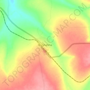
Name: Mutshatsha topographic map, elevation, terrain.
Location: Mutshatsha, Lualaba, Democratic Republic of the Congo (-10.68328 24.42096 -10.60328 24.50096)
Average elevation: 1,235 m
Minimum elevation: 1,182 m
Maximum elevation: 1,278 m
Other topographic maps
Click on a map to view its topography, its elevation and its terrain.
Musonoie
Democratic Republic of the Congo > Lualaba > Mutshatsha
Musonoie, Mutshatsha, Lualaba, Democratic Republic of the Congo
Average elevation: 1,462 m
Kapata
Democratic Republic of the Congo > Lualaba > Mutshatsha
Kapata, Mutshatsha, Lualaba, Democratic Republic of the Congo
Average elevation: 1,470 m
Luilu
Democratic Republic of the Congo > Lualaba > Mutshatsha
Luilu, Mutshatsha, Lualaba, Democratic Republic of the Congo
Average elevation: 1,424 m