
Make a donation
Lindi Region topographic map
Click on the map to display elevation.
Make a donation
Lindi Region
The region is divided into two main agro-ecological zones; the coastal zone which is the main cultivation of tree crops such as cashew, coconut and mango. These areas are Lindi and Kilwa districts respectively with an elevation of 0 to 400 meters. Roughly 10% of farmers commercially grow cashews for export. The second agro-ecological zone is the midlands where the main cultivation of crops include maize, African rice, sesame and cassava. These areas are mostly Liwale and Nachingwea districts with an elevation of 300 to 900 meters above sea level. Rearing of livestock is still low in Lindi compared to other regions.
Make a donation
About this map
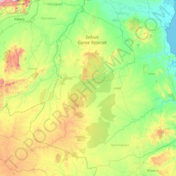
Name: Lindi Region topographic map, elevation, terrain.
Location: Lindi Region, Coastal Zone, Tanzania (-10.73757 36.86896 -7.93453 39.98170)
Average elevation: 402 m
Minimum elevation: 0 m
Maximum elevation: 2,228 m
Make a donation
Other topographic maps
Click on a map to view its topography, its elevation and its terrain.
Dodoma
The official capital since 1996, Dodoma was envisaged as the first non-monumental capital city as opposed to the monumentality and hierarchy of other planned capital cities such as Abuja, Yamoussoukro, Brasília and Washington, D.C. It rejected geometrical forms such as grid iron and radial plans as…
Average elevation: 1,144 m
Mwanza
Mwanza features a tropical savanna climate under the Köppen climate classification. Temperatures are relatively consistent throughout the course of the year, tempered by the city's altitude. Thus, the climate is not quite as hot as one might expect, given the city's location near the equator. Average…
Average elevation: 1,178 m
Make a donation
Make a donation
Make a donation
Mbeya
Mbeya is situated at an altitude of 1,700 metres (5,500 ft), and sprawls through a narrow highland valley surrounded by a bowl of high mountains. The main language is colloquial Swahili, and the English language is extensively taught in schools.
Average elevation: 1,817 m
Make a donation
Make a donation