
Make a donation
Mpwapwa topographic map
Click on the map to display elevation.
Make a donation
About this map
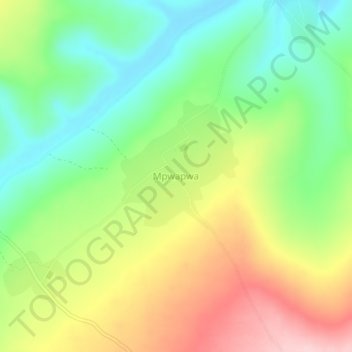
Name: Mpwapwa topographic map, elevation, terrain.
Location: Mpwapwa, Newala, Coastal Zone, Tanzania (-10.71293 39.24782 -10.67293 39.28782)
Average elevation: 465 m
Minimum elevation: 376 m
Maximum elevation: 589 m
Make a donation
Other topographic maps
Click on a map to view its topography, its elevation and its terrain.
Morogoro Region
The Morogoro region has a total size of 73,039 square kilometers, which is split between land (70,967 square kilometers, or 97.2 percent of the total area), and water (2,073 km2 or 2.8 percent). As of 2012, Ulanga District is the largest district,Malinyi DC comes in second with 17.0 percent of the region's…
Average elevation: 539 m
Make a donation
Dodoma
The official capital since 1996, Dodoma was envisaged as the first non-monumental capital city as opposed to the monumentality and hierarchy of other planned capital cities such as Abuja, Yamoussoukro, Brasília and Washington, D.C. It rejected geometrical forms such as grid iron and radial plans as…
Average elevation: 1,144 m
Lindi Region
The region is divided into two main agro-ecological zones; the coastal zone which is the main cultivation of tree crops such as cashew, coconut and mango. These areas are Lindi and Kilwa districts respectively with an elevation of 0 to 400 meters. Roughly 10% of farmers commercially grow cashews for export.…
Average elevation: 402 m
Make a donation
Mbeya Region
The Great Rift Valley created the majority of the places in the area, with the lowland elevation occupying the Western Rift Zone, which includes the Lake Rukwa and Lake Nyasa regions, and the Eastern Rift Zone, which includes the Usangu Plains and other sections of the Ruaha Trough. The heights range from 475…
Average elevation: 1,314 m
Make a donation
Make a donation