
Make a donation
Taranaki topographic map
Click on the map to display elevation.
Make a donation
About this map
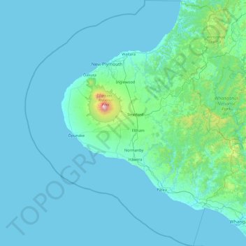
Name: Taranaki topographic map, elevation, terrain.
Location: Taranaki, New Zealand (-40.06785 173.49249 -38.70161 174.99176)
Average elevation: 104 m
Minimum elevation: -1 m
Maximum elevation: 2,402 m
Make a donation
Other topographic maps
Click on a map to view its topography, its elevation and its terrain.
Mount Cook
New Zealand > Canterbury > Mackenzie District
Aoraki / Mount Cook is the highest mountain in New Zealand. Its height, as of 2014, is listed as 3,724 metres (12,218 feet). It sits in the Southern Alps, the mountain range that runs the length of the South Island. A popular tourist destination, it is also a favourite challenge for mountain climbers. Aoraki /…
Average elevation: 2,920 m
Make a donation
Make a donation
Naseby
New Zealand > Otago > Central Otago District
Naseby is a small town, formerly a borough, in the Maniototo area of Central Otago, New Zealand. It is named after a village in Northamptonshire, England, which was the site of a major battle during the English Civil War. Previous names of the township were Parker's, Hogburn and Mt Ida. The town catch phrase…
Average elevation: 619 m
Make a donation
Make a donation
Taipa River
New Zealand > Northland > Far North District > Te Hiku Community > Cable Bay
Average elevation: 25 m
Make a donation
Lake Roxburgh
New Zealand > Otago > Central Otago District > Teviot Valley Community
Average elevation: 211 m
Moerewa
New Zealand > Northland > Far North District > Bay of Islands-Whangaroa Community
Average elevation: 89 m
Make a donation
Make a donation
Taumarunui
New Zealand > Manawatu-Whanganui > Ruapehu District
Under the Köppen, Taumarunui has an Oceanic climate:(Cfb). Due to location, low altitude and Geography surroundings, Taumarunui is more liable to warm to hot summers than other central North Island centres and in winter, Taumarunui is cold and frosty. Rainfall yearly is 1,449 mm (57.047244 in). Annual…
Average elevation: 245 m
Make a donation
Make a donation
Make a donation
Make a donation
Make a donation
Cape Kidnappers / Te Kauwae-a-Māui
New Zealand > Hawke's Bay > Hastings District
Average elevation: 16 m
Make a donation
Central Otago
New Zealand > Otago > Central Otago District > Vincent Community
Average elevation: 935 m
Make a donation
Ohinepaka Bay
New Zealand > Canterbury > Christchurch City > Banks Peninsula Community > Wainui
Average elevation: 94 m
Sutherland Falls
New Zealand > Southland > Southland District > Fiordland Community
Average elevation: 1,006 m
Make a donation
South Featherston
New Zealand > Wellington > South Wairarapa District > Featherston Community > Featherston
Average elevation: 26 m
Make a donation
Glenham
New Zealand > Southland > Southland District > Waihopai Toetoe Community
Average elevation: 109 m
Make a donation
Make a donation
Zig Zag
New Zealand > Canterbury > Christchurch City > Banks Peninsula Community
Average elevation: 136 m
Make a donation
Make a donation
Mount Mackenzie
New Zealand > Southland > Southland District > Fiordland Community
Average elevation: 1,170 m
Make a donation
Make a donation
Oban
New Zealand > Southland > Southland District > Stewart Island / Rakiura Community
Average elevation: 23 m
Make a donation
Make a donation
Hanmer Springs
New Zealand > Canterbury > Hurunui District
The Jacks Pass – Clarence River – Jollies Pass Loop is a 25 kilometer loop which is not technically challenging however it takes between two to four hours to complete. It can be ridden in either direction: West over Jacks Pass (869m) or East over Jollies Pass (850m). As the entire ride is at high elevation…
Average elevation: 397 m
Make a donation