
Make a donation
Brookfield topographic map
Click on the map to display elevation.
Make a donation
About this map
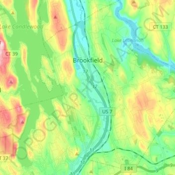
Name: Brookfield topographic map, elevation, terrain.
Average elevation: 139 m
Minimum elevation: 57 m
Maximum elevation: 297 m
Make a donation
Other topographic maps
Click on a map to view its topography, its elevation and its terrain.
Shippan Point
United States > Connecticut > Western Connecticut Planning Region > Stamford
Average elevation: 3 m
Cos Cob
United States > Connecticut > Western Connecticut Planning Region > Greenwich
Average elevation: 17 m
Brookfield Center
United States > Connecticut > Western Connecticut Planning Region > Brookfield
Average elevation: 133 m
North Wilton
United States > Connecticut > Western Connecticut Planning Region > Wilton
Average elevation: 138 m
Make a donation
Cedarhurst
United States > Connecticut > Western Connecticut Planning Region > Newtown
Average elevation: 111 m
Pine Hill
United States > Connecticut > Western Connecticut Planning Region > Greenwich
Average elevation: 88 m
Mill River Park
United States > Connecticut > Western Connecticut Planning Region > Stamford
Average elevation: 18 m
Winnipauk Village
United States > Connecticut > Western Connecticut Planning Region > Norwalk
Average elevation: 34 m
Make a donation
Sellecks Corners
United States > Connecticut > Western Connecticut Planning Region > New Canaan
Average elevation: 137 m
Putnam Memorial State Park
United States > Connecticut > Western Connecticut Planning Region > Redding
Average elevation: 215 m
Norwalk River
United States > Connecticut > Western Connecticut Planning Region > Wilton > Cannondale
Average elevation: 106 m
Darien Pond
United States > Connecticut > Western Connecticut Planning Region > New Canaan
Average elevation: 71 m
Make a donation
Ponus
United States > Connecticut > Western Connecticut Planning Region > New Canaan
Average elevation: 77 m
North Stamford
United States > Connecticut > Western Connecticut Planning Region > Stamford
Average elevation: 89 m
Ball Pond
United States > Connecticut > Western Connecticut Planning Region > New Fairfield
Average elevation: 222 m
Bigelow Corners
United States > Connecticut > Western Connecticut Planning Region > New Fairfield
Average elevation: 222 m
Make a donation
Bogus Hill
United States > Connecticut > Western Connecticut Planning Region > New Fairfield
Average elevation: 161 m
Candlewood Isle
United States > Connecticut > Western Connecticut Planning Region > New Fairfield
Average elevation: 176 m
Candlewood Knolls
United States > Connecticut > Western Connecticut Planning Region > New Fairfield
Average elevation: 176 m
Candlewood Orchards
United States > Connecticut > Western Connecticut Planning Region > Brookfield
Average elevation: 141 m
Make a donation
Candlewood Shores
United States > Connecticut > Western Connecticut Planning Region > Brookfield
Average elevation: 144 m
Dodgingtown
United States > Connecticut > Western Connecticut Planning Region > Newtown
Average elevation: 180 m
Hawleyville
United States > Connecticut > Western Connecticut Planning Region > Newtown
Average elevation: 145 m
Knollcrest
United States > Connecticut > Western Connecticut Planning Region > New Fairfield
Average elevation: 185 m
Make a donation
Mamanasco Lake Dam
United States > Connecticut > Western Connecticut Planning Region > Ridgefield
Average elevation: 210 m
Mill Plain
United States > Connecticut > Western Connecticut Planning Region > Danbury
Average elevation: 190 m
Ridgebury
United States > Connecticut > Western Connecticut Planning Region > Ridgefield
Average elevation: 195 m
Rock Ridge
United States > Connecticut > Western Connecticut Planning Region > Greenwich
Average elevation: 45 m
Make a donation
South Wilton
United States > Connecticut > Western Connecticut Planning Region > Wilton
Average elevation: 70 m
Tokeneke
United States > Connecticut > Western Connecticut Planning Region > Darien
Average elevation: 14 m
Topstone
United States > Connecticut > Western Connecticut Planning Region > Redding
Average elevation: 171 m
West Mountain
United States > Connecticut > Western Connecticut Planning Region > Ridgefield
Average elevation: 242 m
Make a donation
Hattertown
United States > Connecticut > Western Connecticut Planning Region > Newtown
Average elevation: 182 m
Richards Corner
United States > Connecticut > Western Connecticut Planning Region > New Canaan
Average elevation: 122 m
Riverbank
United States > Connecticut > Western Connecticut Planning Region > Stamford
Average elevation: 72 m
Roxbury
United States > Connecticut > Western Connecticut Planning Region > Stamford
Average elevation: 48 m
Make a donation
Silvermine
United States > Connecticut > Western Connecticut Planning Region > Norwalk
Average elevation: 65 m
Pemberwick
United States > Connecticut > Western Connecticut Planning Region > Greenwich
Average elevation: 45 m
Noroton
United States > Connecticut > Western Connecticut Planning Region > Darien
Average elevation: 18 m
Botsford
United States > Connecticut > Western Connecticut Planning Region > Newtown
Average elevation: 140 m
Make a donation
Glenville
United States > Connecticut > Western Connecticut Planning Region > Greenwich
Average elevation: 54 m