
Thank you for supporting this site ❤️
Make a donation
Make a donation
West Mountain topographic map
Click on the map to display elevation.
Thank you for supporting this site ❤️
Make a donation
Make a donation
About this map
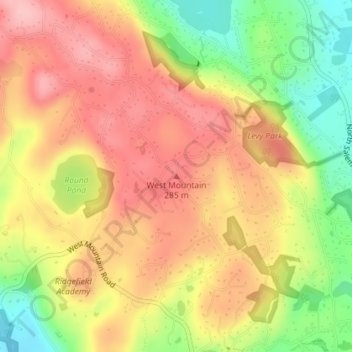
Name: West Mountain topographic map, elevation, terrain.
Average elevation: 242 m
Minimum elevation: 159 m
Maximum elevation: 301 m
Thank you for supporting this site ❤️
Make a donation
Make a donation
Other topographic maps
Click on a map to view its topography, its elevation and its terrain.
Ridgefield
United States > Connecticut > Western Connecticut Planning Region > Ridgefield
Average elevation: 205 m
Mamanasco Lake Dam
United States > Connecticut > Western Connecticut Planning Region > Ridgefield
Average elevation: 210 m