
Thank you for supporting this site ❤️
Make a donation
Make a donation
Darien Pond topographic map
Click on the map to display elevation.
Thank you for supporting this site ❤️
Make a donation
Make a donation
About this map
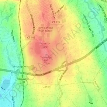
Name: Darien Pond topographic map, elevation, terrain.
Average elevation: 71 m
Minimum elevation: 30 m
Maximum elevation: 106 m
Thank you for supporting this site ❤️
Make a donation
Make a donation
Other topographic maps
Click on a map to view its topography, its elevation and its terrain.
Sellecks Corners
United States > Connecticut > Western Connecticut Planning Region > New Canaan
Average elevation: 137 m
Ponus
United States > Connecticut > Western Connecticut Planning Region > New Canaan
Average elevation: 77 m
Richards Corner
United States > Connecticut > Western Connecticut Planning Region > New Canaan
Average elevation: 122 m