
Thank you for supporting this site ❤️
Make a donation
Make a donation
North Wilton topographic map
Click on the map to display elevation.
Thank you for supporting this site ❤️
Make a donation
Make a donation
About this map
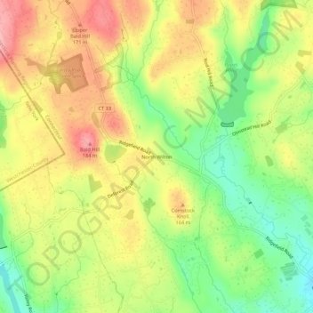
Name: North Wilton topographic map, elevation, terrain.
Average elevation: 138 m
Minimum elevation: 75 m
Maximum elevation: 199 m
Thank you for supporting this site ❤️
Make a donation
Make a donation
Other topographic maps
Click on a map to view its topography, its elevation and its terrain.
Norwalk River
United States > Connecticut > Western Connecticut Planning Region > Wilton > Cannondale
Average elevation: 106 m
Georgetown
United States > Connecticut > Western Connecticut Planning Region > Wilton
Average elevation: 143 m