Geolocate

Héron topographic map

Interactive map

Click on the map to display elevation.

About this map

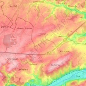
Name: Héron topographic map, elevation, terrain.

Location: Héron, Huy, Liège, Wallonia, 4217, Belgium (50.50351 5.03421 50.57921 5.17248)

Average elevation: 166 m

Minimum elevation: 63 m

Maximum elevation: 221 m

Other topographic maps

Click on a map to view its topography, its elevation and its terrain.

Ferrières

Belgium > Liège > Huy

Ferrières, Huy, Liège, Wallonia, 4190, Belgium

Average elevation: 290 m

My

Belgium > Liège > Huy

My, Ferrières, Huy, Liège, Wallonia, 4190, Belgium

Average elevation: 244 m

Ocquier

Belgium > Liège > Huy > Ocquier

Ocquier, Clavier, Huy, Liège, Wallonia, 4560, Belgium

Average elevation: 270 m

Hamoir

Belgium > Liège > Huy > Hamoir

Hamoir, Huy, Liège, Wallonia, 4180, Belgium

Average elevation: 213 m

Ourthe

Belgium > Liège > Huy > Hamoir

Ourthe, Hamoir, Huy, Liège, Wallonia, 4180, Belgium

Average elevation: 179 m

Wanze

Belgium > Liège > Huy

Wanze, Huy, Liège, Wallonia, 4520, Belgium

Average elevation: 142 m