
Thank you for supporting this site ❤️
Make a donation
Make a donation
Pavlodar Region topographic map
Click on the map to display elevation.
Thank you for supporting this site ❤️
Make a donation
Make a donation
About this map
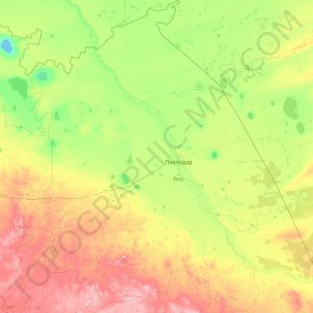
Name: Pavlodar Region topographic map, elevation, terrain.
Location: Pavlodar Region, Kazakhstan (50.01344 73.40578 54.45777 79.34714)
Average elevation: 207 m
Minimum elevation: 26 m
Maximum elevation: 993 m
Thank you for supporting this site ❤️
Make a donation
Make a donation
Other topographic maps
Click on a map to view its topography, its elevation and its terrain.
Qulsarı
Kazakhstan > Atyrau Region > Zhylyoi District > Құлсары қалалық әкімдігі
Average elevation: -11 m
Bulaq
Kazakhstan > North Kazakhstan Region > Esil District > Булакский сельский округ
Average elevation: 180 m
Border Kazakhstan - Russia
Kazakhstan > East Kazakhstan Region > Katonkaragay District
Average elevation: 2,676 m
Thank you for supporting this site ❤️
Make a donation
Make a donation