
Make a donation
Edo State topographic map
Click on the map to display elevation.
Make a donation
Edo State
Edo state has a Tropical wet and dry or savanna climate with yearly temperature of 28.78°C (83.8°F) and it is -0.68% lower than Nigeria's averages. Edo typically receives about 183.49 millimeters (7.22 inches) of precipitation and has 265.91 rainy days (72.85% of the time) annually and at an elevation of 239.16 meters (784.65 feet) above sea level.
Make a donation
About this map
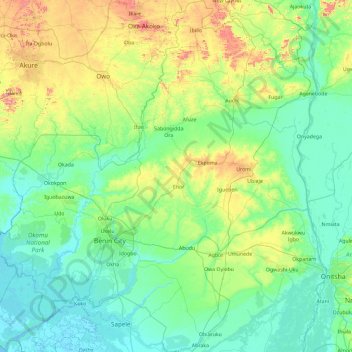
Name: Edo State topographic map, elevation, terrain.
Location: Edo State, Nigeria (5.74639 5.00847 7.59142 6.71577)
Average elevation: 140 m
Minimum elevation: -2 m
Maximum elevation: 873 m
Make a donation
Other topographic maps
Click on a map to view its topography, its elevation and its terrain.
Make a donation
Make a donation
Make a donation
Ibadan
Nigeria > Oyo State > Ibadan South West
Ibadan, coined from the phrase "Eba-Odan", which literally means 'by the edge of the meadow', came into existence in 1829, during a period of turmoil that characterized Yorubaland at the time. It was in this period that many old Yoruba cities such as old Oyo (Oyo-ile), Ijaye and Owu disappeared, and newer ones…
Average elevation: 191 m
Make a donation
Omu Aran
Nigeria > Kwara State > Irepodun
Omu Aran has a tropical wet and dry or savanna climate and is located at an elevation of 536.14 meters (1758.99 feet) above sea level (Classification: Aw). The district's average annual temperature is 0.26% higher than Nigeria's averages at 29.72°C (85.5°F). Omu Aran generally has 149.31 wet days per year…
Average elevation: 539 m
Make a donation
Make a donation
Make a donation
Make a donation