
Murray County topographic map
Interactive map
Click on the map to display elevation.
About this map
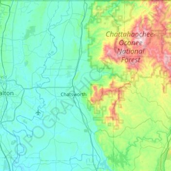
Name: Murray County topographic map, elevation, terrain.
Location: Murray County, Georgia, United States (34.58369 -84.94451 34.98839 -84.58493)
Average elevation: 381 m
Minimum elevation: 188 m
Maximum elevation: 1,252 m
Other topographic maps
Click on a map to view its topography, its elevation and its terrain.
Social Circle
United States > Georgia > Walton County
Social Circle, Walton County, Georgia, 30025, United States
Average elevation: 238 m
Schley County
Schley County, Georgia, 31806, United States
Average elevation: 148 m
Wilkinson County
Wilkinson County, Georgia, United States
Average elevation: 104 m
Canton
United States > Georgia > Cherokee County
Canton, Cherokee County, Georgia, 30114, United States
Average elevation: 320 m
Tired Creek Lake
United States > Georgia > Grady County
Tired Creek Lake, Grady County, Georgia, United States
Average elevation: 80 m
Cartersville
United States > Georgia > Bartow County
Cartersville, Bartow County, Georgia, 30120, United States
Average elevation: 260 m
Dunwoody
United States > Georgia > DeKalb County
Dunwoody, DeKalb County, Georgia, United States
Average elevation: 313 m
Ritch
United States > Georgia > Wayne County
Ritch, Wayne County, Georgia, 31056, United States
Average elevation: 40 m
Spalding County
Spalding County, Georgia, United States
Average elevation: 247 m
Habersham County
United States > Georgia > Habersham County
Habersham County, Georgia, United States
Average elevation: 448 m
Atlanta
United States > Georgia > Fulton County > Atlanta
Atlanta, Fulton County, Georgia, 30303-3506, United States
Average elevation: 285 m
Augusta
United States > Georgia > Richmond County > Augusta
Augusta, Richmond County, Georgia, United States
Average elevation: 89 m
Roswell
United States > Georgia > Fulton County > Roswell
Roswell, Fulton County, Georgia, 30077, United States
Average elevation: 312 m
Suwanee
United States > Georgia > Gwinnett County > Suwanee
Suwanee, Gwinnett County, Georgia, 30024, United States
Average elevation: 311 m
Savannah
United States > Georgia > Chatham County
Savannah, Chatham County, Georgia, United States
Average elevation: 4 m