
Make a donation
Murray County topographic map
Click on the map to display elevation.
Make a donation
About this map
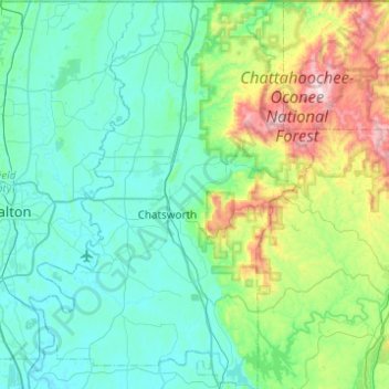
Name: Murray County topographic map, elevation, terrain.
Location: Murray County, Georgia, United States (34.58369 -84.94451 34.98839 -84.58493)
Average elevation: 381 m
Minimum elevation: 188 m
Maximum elevation: 1,252 m
Make a donation
Other topographic maps
Click on a map to view its topography, its elevation and its terrain.
Lake Sal Dam
United States > Georgia > Bulloch County > Statesboro > Pate Place
Average elevation: 64 m
Atlanta
United States > Georgia > Fulton County > Atlanta
Atlanta (/ætˈlæntə/ at-LAN-tə) is the capital and most populous city of the U.S. state of Georgia. With a 2020 census population of 498,715, it is the eighth-most populous city in the Southeast and 38th most populous city in the United States. It serves as the cultural and economic center of the Atlanta…
Average elevation: 285 m
Make a donation