
Curacao topographic map
Interactive map
Click on the map to display elevation.
About this map
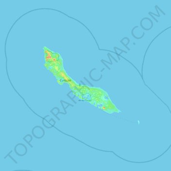
Name: Curacao topographic map, elevation, terrain.
Location: Curacao, Netherlands (11.77700 -69.36735 12.59200 -68.44133)
Average elevation: 2 m
Minimum elevation: -1 m
Maximum elevation: 288 m
Curaçao, as well as the rest of the ABC islands and Trinidad and Tobago, lies on the continental shelf of South America. It is a thin island with a generally hilly topography; the highest point is Christoffelberg in the northwest, with a peak at 372 m (1,220 ft) above sea level. The coastline's bays, inlets and hot springs offer a source of natural minerals, thermal conditions, and seawater used in hydrotherapy and mesotherapy, making the island one of many balneoclimateric areas in the region. Off the southeast coast lies the small, flat island of Klein Curaçao.
Other topographic maps
Click on a map to view its topography, its elevation and its terrain.
India
India
Average elevation: 1,017 m
Sri Lanka
Sri Lanka
Average elevation: 50 m
Montreal
Canada > Quebec > Urban agglomeration of Montreal > Montreal
Montreal, Urban agglomeration of Montreal, Montreal (06), Quebec, H3B 1M7, Canada
Average elevation: 30 m
Hyderabad
India > Telangana > Bahadurpura mandal
Hyderabad, Bahadurpura mandal, Hyderabad District, Telangana, India
Average elevation: 549 m
Bengaluru
India > Karnataka > Bangalore North
Bengaluru, Bangalore North, Bengaluru Urban District, Karnataka, India
Average elevation: 881 m
Snohomish County
Snohomish County, Washington, United States
Average elevation: 649 m
Kandy
Kandy, Kandy District, Central Province, 20000, Sri Lanka
Average elevation: 621 m
Tacoma
United States > Washington > Pierce County
Tacoma, Pierce County, Washington, United States
Average elevation: 67 m
Ooty Lake
India > Tamil Nadu > Udhagamandalam > Udhagamandalam
Ooty Lake, Udhagamandalam, The Nilgiris District, Tamil Nadu, 643001, India
Average elevation: 2,235 m
Mangerton
Australia > New South Wales > Wollongong City Council
Mangerton, Wollongong City Council, New South Wales, 2500, Australia
Average elevation: 31 m
Sujanpur
India > Punjab > Pathankot Tahsil
Sujanpur, Pathankot Tahsil, Pathankot District, Punjab, 145023, India
Average elevation: 334 m
Pedda Arikatla
India > Andhra Pradesh > Konakanamitla
Pedda Arikatla, Konakanamitla, Prakasam, Andhra Pradesh, 523245, India
Average elevation: 119 m
Nepal
Nepal
Average elevation: 2,604 m
Ocheretyne
Ocheretyne, Ocheretyne settlement hromada, Pokrovskii Raion, Donetsk Oblast, 86020, Ukraine
Average elevation: 227 m
Gandhipuram
India > Tamil Nadu > Coonoor
Gandhipuram, Coonoor, Nilgiris District, Tamil Nadu, 643103, India
Average elevation: 1,686 m
Sion Fort
India > Maharashtra > Mumbai
Sion Fort, Road No 1, Sion Koliwada, F/N Ward, Zone 2, Mumbai, Maharashtra, 400022, India
Average elevation: 6 m
Musti
India > Maharashtra > Solapur South
Musti, Solapur South, Solapur District, Maharashtra, 413573, India
Average elevation: 487 m
Mambakkam
India > Tamil Nadu > Tiruporur
Mambakkam, Tiruporur, Chengalpattu District, Tamil Nadu, 600127, India
Average elevation: 16 m
Haywood County
United States > North Carolina
Haywood County, North Carolina, United States
Average elevation: 1,044 m
Show Low
United States > Arizona > Navajo County
Show Low, Navajo County, Arizona, 85901, United States
Average elevation: 1,957 m
Mangaluru
India > Karnataka > Mangaluru taluk
Mangaluru, Mangaluru taluk, Dakshina Kannada District, Karnataka, 575001, India
Average elevation: 25 m
Colombo
Colombo, Colombo District, Western Province, Sri Lanka
Average elevation: 5 m
Siliguri
India > West Bengal > Siliguri Subdivsion
Siliguri, Siliguri Subdivsion, Darjeeling District, West Bengal, India
Average elevation: 121 m
Vadodara
India > Gujarat > Vadodara Taluka
Vadodara, Vadodara Taluka, Vadodara District, Gujarat, 390001, India
Average elevation: 36 m
Dehradun
India > Uttarakhand > Dehradun
Dehradun, Dehradun District, Uttarakhand, 248001, India
Average elevation: 904 m
Kharki
India > Madhya Pradesh > Pandhana Tahsil
Kharki, Pandhana Tahsil, Khandwa District, Madhya Pradesh, India
Average elevation: 317 m
Kannamedi
India > Karnataka > Pavagada taluk
Kannamedi, Pavagada taluk, Tumakuru District, Karnataka, India
Average elevation: 708 m