
Saas-Fee topographic map
Interactive map
Click on the map to display elevation.
About this map
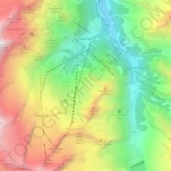
Name: Saas-Fee topographic map, elevation, terrain.
Location: Saas-Fee, Visp, Wallis, 3906, Schweiz (46.04609 7.85721 46.12524 7.94542)
Average elevation: 2,673 m
Minimum elevation: 1,560 m
Maximum elevation: 4,272 m
Vor ca. 700 Jahren setzten die sog. Walserwanderungen ein; viele Saaser verliessen wegen fehlender Existenzgrundlagen und Aussicht auf mehr Freiheiten ihre Heimat. Sie zogen über die Pässe nach Italien und liessen sich auf rauen Höhenlagen in den Walsersiedlungen Macugnaga und Antronapiana nieder.
Other topographic maps
Click on a map to view its topography, its elevation and its terrain.
Stalden (VS)
Stalden (VS), Visp, Wallis, 3922, Schweiz
Average elevation: 1,532 m
Dufourspitze
Schweiz > Wallis > Visp > Zermatt
Dufourspitze, Zermatt, Visp, Wallis, 3920, Schweiz
Average elevation: 4,033 m
Klein Matterhorn
Schweiz > Wallis > Visp > Zermatt
Klein Matterhorn, Zermatt, Visp, Wallis, 3920, Schweiz
Average elevation: 3,515 m
Gornergrat
Schweiz > Wallis > Visp > Zermatt
Gornergrat, Gornergrat - Hohtälli, Zermatt, Visp, Wallis, 3920, Schweiz
Average elevation: 2,768 m