
Zermatt topographic map
Interactive map
Click on the map to display elevation.
About this map
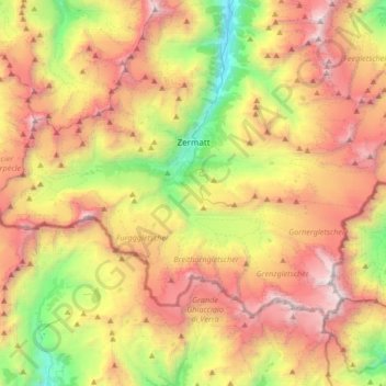
Name: Zermatt topographic map, elevation, terrain.
Location: Zermatt, Visp, Wallis, 3920, Schweiz (45.91670 7.57538 46.06428 7.90870)
Average elevation: 2,921 m
Minimum elevation: 1,406 m
Maximum elevation: 4,619 m
Zermatt ([tsɛrˈmat]) ist eine politische Gemeinde und eine Burgergemeinde mit einem Burgerrat im Bezirk Visp sowie eine Pfarrgemeinde des Dekanats Visp im Schweizer Kanton Wallis. Bevölkerungsmässig ist Zermatt nach Visp zweitgrösster Ort im Bezirk Visp und liegt im Mattertal auf einer Höhe von zirka 1610 m am Nordostfuss des Matterhorns. Zermatt ist ein Bergsteigerzentrum und dank des Matterhorns und seines Wintersport- und Wandergebietes ein bekannter Ferienort der Schweiz.
Other topographic maps
Click on a map to view its topography, its elevation and its terrain.
Stalden (VS)
Stalden (VS), Visp, Wallis, 3922, Schweiz
Average elevation: 1,532 m
Dufourspitze
Schweiz > Wallis > Visp > Zermatt
Dufourspitze, Zermatt, Visp, Wallis, 3920, Schweiz
Average elevation: 4,033 m
Klein Matterhorn
Schweiz > Wallis > Visp > Zermatt
Klein Matterhorn, Zermatt, Visp, Wallis, 3920, Schweiz
Average elevation: 3,515 m
Gornergrat
Schweiz > Wallis > Visp > Zermatt
Gornergrat, Gornergrat - Hohtälli, Zermatt, Visp, Wallis, 3920, Schweiz
Average elevation: 2,768 m