
Visp topographic map
Interactive map
Click on the map to display elevation.
About this map
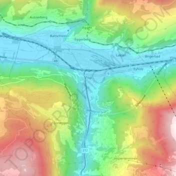
Name: Visp topographic map, elevation, terrain.
Location: Visp, Wallis, 3930, Schweiz (46.27092 7.82999 46.30313 7.93154)
Average elevation: 1,195 m
Minimum elevation: 634 m
Maximum elevation: 2,237 m
Für die Normalperiode 1991–2020 beträgt die Jahresmitteltemperatur 9,9 °C, wobei im Januar mit −0,7 °C die kältesten und im Juli mit 19,8 °C die wärmsten Monatsmitteltemperaturen gemessen werden. Im Mittel sind hier rund 111 Frosttage und 17 Eistage zu erwarten. Sommertage gibt es im Jahresmittel rund 72, während durchschnittlich 20 Hitzetage zu verzeichnen sind. Die Messstation von MeteoSchweiz liegt auf einer Höhe von 639 m ü. M.
Other topographic maps
Click on a map to view its topography, its elevation and its terrain.
Stalden (VS)
Stalden (VS), Visp, Wallis, 3922, Schweiz
Average elevation: 1,532 m
Dufourspitze
Schweiz > Wallis > Visp > Zermatt
Dufourspitze, Zermatt, Visp, Wallis, 3920, Schweiz
Average elevation: 4,033 m
Klein Matterhorn
Schweiz > Wallis > Visp > Zermatt
Klein Matterhorn, Zermatt, Visp, Wallis, 3920, Schweiz
Average elevation: 3,515 m
Gornergrat
Schweiz > Wallis > Visp > Zermatt
Gornergrat, Gornergrat - Hohtälli, Zermatt, Visp, Wallis, 3920, Schweiz
Average elevation: 2,768 m