
Make a donation
Weißensberg topographic map
Click on the map to display elevation.
Make a donation
About this map
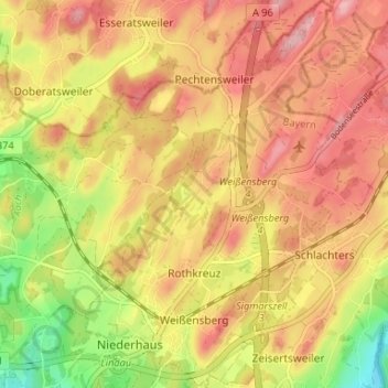
Name: Weißensberg topographic map, elevation, terrain.
Average elevation: 506 m
Minimum elevation: 422 m
Maximum elevation: 563 m
Make a donation
Other topographic maps
Click on a map to view its topography, its elevation and its terrain.
Make a donation
Dürren
Deutschland > Bayern > Landkreis Lindau > Lindau (Bodensee) > Oberreitnau
Stadtteile: Aeschach | Bad Schachen | Degelstein | Hochbuch | Hoyren | Insel | Oberreutin | Reutin | Rickenbach | Schönau | Wannental | Zech Pfarrdörfer: Oberreitnau | Unterreitnau Dörfer: Bechtersweiler | Eggatsweiler | Heimesreutin | Höhenreute | Hörbolz | Motzach | Niederhaus | Oberhochsteg |…
Average elevation: 482 m
Make a donation
Make a donation
Oberreutin
Deutschland > Bayern > Landkreis Lindau > Lindau (Bodensee)
Stadtteile: Aeschach | Bad Schachen | Degelstein | Hochbuch | Hoyren | Insel | Oberreutin | Reutin | Rickenbach | Schönau | Wannental | Zech Pfarrdörfer: Oberreitnau | Unterreitnau Dörfer: Bechtersweiler | Eggatsweiler | Heimesreutin | Höhenreute | Hörbolz | Motzach | Niederhaus | Oberhochsteg |…
Average elevation: 433 m
Rentershofen
Deutschland > Bayern > Landkreis Lindau > Röthenbach (Allgäu) > Oberhäuser
Average elevation: 705 m
Make a donation
Obere Weberei
Deutschland > Bayern > Landkreis Lindau > Weiler-Simmerberg > Weiler im Allgäu
Average elevation: 696 m
Höhenreute
Deutschland > Bayern > Landkreis Lindau > Lindau (Bodensee)
Höhenreute (mundartlich: Heritə) ist ein Gemeindeteil der bayerisch-schwäbischen Großen Kreisstadt Lindau (Bodensee).
Average elevation: 492 m
Wannental
Deutschland > Bayern > Landkreis Lindau > Lindau (Bodensee)
Stadtteile: Aeschach | Bad Schachen | Degelstein | Hochbuch | Hoyren | Insel | Oberreutin | Reutin | Rickenbach | Schönau | Wannental | Zech Pfarrdörfer: Oberreitnau | Unterreitnau Dörfer: Bechtersweiler | Eggatsweiler | Heimesreutin | Höhenreute | Hörbolz | Motzach | Niederhaus | Oberhochsteg |…
Average elevation: 431 m
Make a donation
Make a donation
Make a donation
Unterried
Deutschland > Bayern > Landkreis Lindau > Heimenkirch
Der Ortsname stammt vom mittelhochdeutschen Wort riet, das Ried, Sumpfgebiet oder ausgereuteter Grund (Rodung) bedeuten kann. Somit bedeutet der Ortsname (Siedlung im/beim) Ried, Sumpfgebiet oder Rodesiedlung. Der Präfix Unter- dient zur Unterscheidung zum höher gelegenen Oberried.
Average elevation: 655 m
Make a donation
Schreckenmanklitz
Deutschland > Bayern > Landkreis Lindau > Weiler-Simmerberg
Average elevation: 717 m
Make a donation
Steig
Deutschland > Bayern > Landkreis Lindau > Grünenbach
Der Ortsname stammt vom mittelhochdeutschen Wort steig(e) für steile Straße bzw. Anhöhe ab.
Average elevation: 844 m
Make a donation
Biesenberg
Deutschland > Bayern > Landkreis Lindau > Meckatz
Der Ortsname setzt sich aus dem Personennamen Buoso und dem Grundwort -berg zusammen. Somit bedeutet der Ortsname (Siedlung an der) Anhöhe des Buoso.
Average elevation: 673 m
Make a donation
Engenberg
Deutschland > Bayern > Landkreis Lindau > Meckatz
Der Ortsname stammt vom Personen(kurz)namen Enge oder Ëmmo und bedeutet somit (Siedlung an) der Anhöhe des Enge/Ëmmo.
Average elevation: 706 m
Make a donation
BSB-Hafen Lindau (Bodensee)
Deutschland > Bayern > Landkreis Lindau > Lindau (Bodensee)
Average elevation: 395 m
Bechtersweiler
Deutschland > Bayern > Landkreis Lindau > Lindau (Bodensee) > Unterreitnau > Bechtersweiler
Average elevation: 471 m
Hörbolz
Deutschland > Bayern > Landkreis Lindau > Lindau (Bodensee)
Stadtteile: Aeschach | Bad Schachen | Degelstein | Hochbuch | Hoyren | Insel | Oberreutin | Reutin | Rickenbach | Schönau | Wannental | Zech Pfarrdörfer: Oberreitnau | Unterreitnau Dörfer: Bechtersweiler | Eggatsweiler | Heimesreutin | Höhenreute | Hörbolz | Motzach | Niederhaus | Oberhochsteg |…
Average elevation: 479 m
Make a donation
Rickatshofen
Deutschland > Bayern > Landkreis Lindau > Lindau (Bodensee) > Unterreitnau
Average elevation: 458 m
Make a donation
Make a donation