
Thank you for supporting this site ❤️
Make a donation
Make a donation
Unterreitnau topographic map
Click on the map to display elevation.
Thank you for supporting this site ❤️
Make a donation
Make a donation
About this map
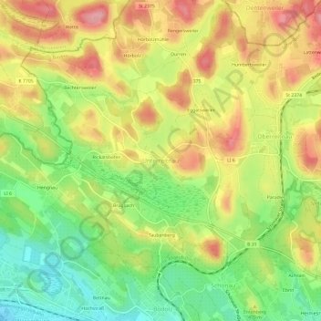
Name: Unterreitnau topographic map, elevation, terrain.
Average elevation: 461 m
Minimum elevation: 398 m
Maximum elevation: 524 m
Thank you for supporting this site ❤️
Make a donation
Make a donation
Other topographic maps
Click on a map to view its topography, its elevation and its terrain.
BSB-Hafen Lindau (Bodensee)
Deutschland > Bayern > Landkreis Lindau > Lindau (Bodensee)
Average elevation: 395 m