
Seedorf (UR) topographic map
Interactive map
Click on the map to display elevation.
About this map
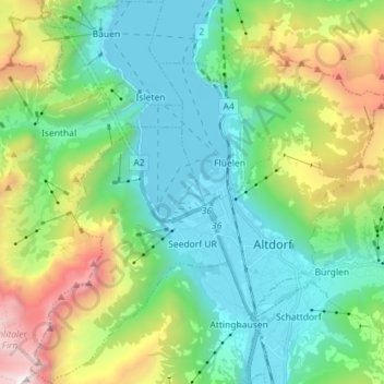
Name: Seedorf (UR) topographic map, elevation, terrain.
Location: Seedorf (UR), Uri, 6462, Schweiz (46.84664 8.55147 46.94382 8.62427)
Average elevation: 1,108 m
Minimum elevation: 422 m
Maximum elevation: 2,925 m
Other topographic maps
Click on a map to view its topography, its elevation and its terrain.
Furkapass
Schweiz > Uri > Korporation Ursern > Realp
Furkapass, Realp, Korporation Ursern, Uri, 6491, Schweiz
Average elevation: 2,470 m
Billenweid
Schweiz > Uri > Bürglen (UR)
Billenweid, Bürglen (UR), Uri, 6463, Schweiz
Average elevation: 1,074 m
Andermatt
Schweiz > Uri > Korporation Ursern
Andermatt, Korporation Ursern, Uri, 6490, Schweiz
Average elevation: 2,127 m