
Andermatt topographic map
Interactive map
Click on the map to display elevation.
About this map
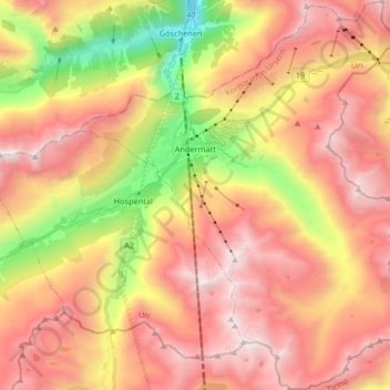
Name: Andermatt topographic map, elevation, terrain.
Location: Andermatt, Korporation Ursern, Uri, 6490, Schweiz (46.56410 8.54654 46.67706 8.68192)
Average elevation: 2,127 m
Minimum elevation: 1,023 m
Maximum elevation: 2,972 m
Other topographic maps
Click on a map to view its topography, its elevation and its terrain.
Furkapass
Schweiz > Uri > Korporation Ursern > Realp
Furkapass, Realp, Korporation Ursern, Uri, 6491, Schweiz
Average elevation: 2,470 m