
Thank you for supporting this site ❤️
Make a donation
Make a donation
Huckleberry topographic map
Click on the map to display elevation.
Thank you for supporting this site ❤️
Make a donation
Make a donation
About this map
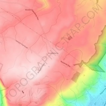
Name: Huckleberry topographic map, elevation, terrain.
Average elevation: 479 m
Minimum elevation: 212 m
Maximum elevation: 568 m
Thank you for supporting this site ❤️
Make a donation
Make a donation
Other topographic maps
Click on a map to view its topography, its elevation and its terrain.
Chattanooga
United States > Tennessee > Hamilton County
According to the United States Census Bureau, the city has a total area of 144.6 square miles (374.4 km2), of which 137.1 square miles (355.2 km2) are land and 7.4 square miles (19.2 km2), or 5.12%, are water. The most prominent natural features in and around Chattanooga are the Tennessee River and the…
Average elevation: 331 m