
Thank you for supporting this site ❤️
Make a donation
Make a donation
North Island topographic map
Click on the map to display elevation.
Thank you for supporting this site ❤️
Make a donation
Make a donation
About this map
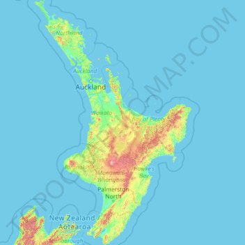
Name: North Island topographic map, elevation, terrain.
Location: North Island, New Zealand (-41.61375 172.64302 -34.39339 178.55050)
Average elevation: 66 m
Minimum elevation: -1 m
Maximum elevation: 2,650 m
Thank you for supporting this site ❤️
Make a donation
Make a donation
Other topographic maps
Click on a map to view its topography, its elevation and its terrain.
Wave
New Zealand > Wellington > South Wairarapa District > Martinborough Community
Average elevation: 162 m
Thank you for supporting this site ❤️
Make a donation
Make a donation
Thank you for supporting this site ❤️
Make a donation
Make a donation
Thank you for supporting this site ❤️
Make a donation
Make a donation
Thank you for supporting this site ❤️
Make a donation
Make a donation
Thank you for supporting this site ❤️
Make a donation
Make a donation
Thank you for supporting this site ❤️
Make a donation
Make a donation
Te Anau
New Zealand > Southland > Southland District > Fiordland Community > Te Anau
Average elevation: 249 m
Thank you for supporting this site ❤️
Make a donation
Make a donation
Oban
New Zealand > Southland > Southland District > Stewart Island/Rakiura Community > Oban
Average elevation: 23 m
Waitangi
New Zealand > Northland > Far North District > Bay of Islands-Whangaroa Community > Waitangi
Average elevation: 15 m
Thank you for supporting this site ❤️
Make a donation
Make a donation