
Make a donation
Ladakh topographic map
Click on the map to display elevation.
Make a donation
Ladakh
The Kargil War of 1999, codenamed "Operation Vijay" by the Indian Army, saw infiltration by Pakistani troops into parts of Western Ladakh, namely Kargil, Dras, Mushkoh, Batalik and Chorbatla, overlooking key locations on the Srinagar-Leh highway. Extensive operations were launched in high altitudes by the Indian Army with considerable artillery and air force support. Pakistani troops were evicted from the Indian side of the Line of Control which the Indian government ordered was to be respected and which was not crossed by Indian troops. The Indian government was criticised by the Indian public because India respected geographical co-ordinates more than India's opponents: Pakistan and China.
Make a donation
About this map
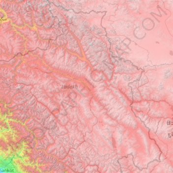
Name: Ladakh topographic map, elevation, terrain.
Location: Ladakh, India (32.33574 75.32697 35.67455 79.46073)
Average elevation: 4,726 m
Minimum elevation: 337 m
Maximum elevation: 7,470 m
Make a donation
Other topographic maps
Click on a map to view its topography, its elevation and its terrain.
Bhavnagar
India > Gujarat > Bhavnagar Taluka
Bhavnagar is a coastal city on the eastern coast of Saurashtra, also known as Kathiawar, located at 21°46′N 72°09′E / 21.77°N 72.15°E / 21.77; 72.15. It has an average elevation of 24 metres (78 ft). It occupies an area of 53.3 km2 (20.6 sq mi) and 5th most populated city of Gujarat. The…
Average elevation: 23 m
Maharashtra
Maharashtra is the third largest state by area in India. The Western Ghats better known as Sahyadri, are a hilly range running parallel to the coast, at an average elevation of 1,200 metres (4,000 ft). Kalsubai, a peak in the Sahyadris, near Nashik city is the highest elevated point in Maharashtra. To the west…
Average elevation: 478 m
Make a donation
Chennai
Chennai is located on the south–eastern coast of India in the north–eastern part of Tamil Nadu on a flat coastal plain known as the Eastern Coastal Plains. Its average elevation is around 6.7 metres (22 ft), and its highest point is 60 m (200 ft). Chennai is 2,184 kilometres (1,357 mi) south of Delhi,…
Average elevation: 7 m
Make a donation
Kotdwar
India > Uttarakhand > Kotdwara
Kotdwar lies on the western margin of the Himalayas, at an altitude of 454 m (1,490 ft) above sea level.
Average elevation: 471 m
Make a donation
Bhubaneshwar
India > Odisha > Bhubaneswar (M.Corp.)
Bhubaneswar is in Khordha district of Odisha. It is in the eastern coastal plains, along the axis of the Eastern Ghats mountains. The city has an average altitude of 45 m (148 ft) above sea level. It lies southwest of the Mahanadi River that forms the northern boundary of Bhubaneswar metropolitan area, within…
Average elevation: 30 m
Gorakhpur
India > Uttar Pradesh > Gorakhpur
Gorakhpur city is located in the north-easterrn part of Uttar Pradesh, India, within the Indo-Gangetic Plain. The city's geographical coordinates are 26.7663° N latitude and 83.3689° E longitude, with an altitude of 69 metres (229 feet) above sea level. Gorakhpur is situated about 100 km from the Nepal…
Average elevation: 79 m
Lucknow
India > Uttar Pradesh > Lucknow
Lucknow stands at an elevation of approximately 123 metres (404 ft) above sea level. The city had an area of 402 km2 (155 square miles) until December 2019, when 88 villages were added to the municipal limits and the area increased to 631 km2 (244 square miles). Bounded on the east by Barabanki, on the west by…
Average elevation: 120 m
Make a donation
Mumbai
Mumbai lies at the mouth of the Ulhas River on the western coast of India, in the coastal region known as the Konkan. It sits on Salsette Island (Sashti Island), which it partially shares with the Thane district. Mumbai is bounded by the Arabian Sea to the west. Many parts of the city lie just above sea level,…
Average elevation: 13 m
Dras
Dras (also spelt Drass, ISO transliteration: Drās), also known locally in Shina as Himababs, Hembabs, or Humas, is a town and hill station, near Kargil in the Kargil district of the union territory of Ladakh in India. It is on the NH 1 between Zoji La pass and Kargil. A tourist hub for its high-altitude…
Average elevation: 3,531 m
Make a donation
Indore
India > Madhya Pradesh > Juni Indore Tahsil
Indore /ɪnˈdɔːr/ (listen) is the most populous and the largest city in the Indian state of Madhya Pradesh. It serves as the headquarters of both Indore District and Indore Division. It is also considered as an education hub of the state and has campuses of both the Indian Institute of Technology and the…
Average elevation: 555 m
Make a donation
Make a donation
Make a donation
Make a donation
Make a donation
Mangaluru
India > Karnataka > Mangaluru taluk
Mangalore is also the administrative headquarters of the Dakshina Kannada district; it is a commercial, industrial, educational, healthcare, and startup hub. The city's international airport is the second-largest and second-busiest airport in Karnataka. Mangalore City Corporation is responsible for the civic…
Average elevation: 25 m
Make a donation
Ranchi
Ranchi lies at 23°22′N 85°20′E / 23.36°N 85.33°E / 23.36; 85.33 near to the Tropic of Cancer. The city covers an area of 175 km2 (68 sq mi) and its average elevation is 651 m above sea level. Ranchi is located in the southern part of the Chota Nagpur plateau, which is the eastern section of…
Average elevation: 648 m
Make a donation
Jasdan
India > Gujarat > Jasdan Taluka
Jasdan is located at 22°02′N 71°12′E / 22.03°N 71.2°E / 22.03; 71.2. It has an average elevation of 293 metres (1633 feet). Jasdan is the biggest Taluka place in Rajkot district and has 103 villages. Geographically it is the heart of the Mandava Hills from where most of the rivers of…
Average elevation: 198 m
Pahalgam
India > Jammu and Kashmir > Pahalgam
Pahalgam (Urdu pronunciation: [pɛɦɛlɡɑːm]) or Pahalgom (Kashmiri pronunciation: [pəhəlʲɡoːm]) is a town in Anantnag district of the Indian union territory of Jammu and Kashmir. It is located on the banks of Lidder River at an altitude of 2,200 m (7,200 ft) in the Vale of Kashmir. Pahalgam is the…
Average elevation: 2,700 m
Make a donation
Lansdowne
India > Uttarakhand > Lansdowne
Lansdowne is a quaint hill station in the Pauri Garhwal district of Uttarakhand, India. Lodged in the picturesque surroundings of the Himalayan ranges, it lies at an elevation of approximately 1,700 meters (5,577 feet) above sea level. The town is about 45 kilometers (28 miles) from the district headquarters,…
Average elevation: 1,140 m
Amritsar
India > Punjab > Amritsar I Tahsil
Amritsar is located at 31°38′N 74°52′E / 31.63°N 74.87°E / 31.63; 74.87 with an average elevation of 234 metres (768 ft) in the Majha region of the state of Punjab in North India and lies about 15 miles (24 km) east of the border with Pakistan. Administrative towns includes Ajnala, Attari,…
Average elevation: 231 m
Make a donation
Make a donation
Make a donation
Cooch Behar
India > West Bengal > Cooch Behar
The elevation of the town is 48 meters above mean sea level.
Average elevation: 43 m
Make a donation
Jammu
India > Jammu and Kashmir > Jammu
Jammu is located at 32°44′N 74°52′E / 32.73°N 74.87°E / 32.73; 74.87. It has an average elevation of 300 m (980 ft). Jammu city lies at uneven ridges of low heights at the Shivalik hills. It is surrounded by the Shivalik range to the north, east, and southeast while the Trikuta Range surrounds…
Average elevation: 367 m
Mussoorie
India > Uttarakhand > Dehradun
Mussoorie is at an average altitude of 2,005 metres (6,578 ft). To the northeast are the Himalayan snow ranges, and to the south, the Doon Valley and Shiwalik ranges. The second highest point is the original Lal Tibba in Landour, with a height of over 2,275 m (7,464 ft). Mussoorie is popularly known as The…
Average elevation: 1,594 m
Make a donation
Bhopal
India > Madhya Pradesh > Huzur Tahsil
Bhopal has an average elevation of 500 metres (1401 ft) and is located in the central part of India, just north of the upper limit of the Vindhya mountain ranges. Located on the Malwa plateau, it is higher than the north Indian plains and the land rises towards the Vindhya Range to the south. The city has…
Average elevation: 498 m
Make a donation
Make a donation
Make a donation
Make a donation
Make a donation
Make a donation
Make a donation