
Muhafazat Tartus topographic map
Interactive map
Click on the map to display elevation.
About this map
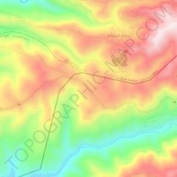
Name: Muhafazat Tartus topographic map, elevation, terrain.
Location: Muhafazat Tartus, Hama, Syrie (34.98450 36.13840 35.02450 36.17840)
Average elevation: 630 m
Minimum elevation: 362 m
Maximum elevation: 877 m
Other topographic maps
Click on a map to view its topography, its elevation and its terrain.
Zawr Rashid al Barazi
Zawr Rashid al Barazi, ناحية حماة, منطقة حماة, Hama, Syrie
Average elevation: 356 m