
Thank you for supporting this site ❤️
Make a donation
Make a donation
Barren County topographic map
Click on the map to display elevation.
Thank you for supporting this site ❤️
Make a donation
Make a donation
About this map
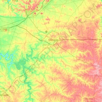
Name: Barren County topographic map, elevation, terrain.
Location: Barren County, Kentucky, United States (36.72273 -86.17641 37.16940 -85.73917)
Average elevation: 231 m
Minimum elevation: 141 m
Maximum elevation: 353 m
Thank you for supporting this site ❤️
Make a donation
Make a donation
Other topographic maps
Click on a map to view its topography, its elevation and its terrain.
Colonel Charles D. Young Park
United States > Kentucky > Jefferson County > Louisville
Average elevation: 138 m
Thank you for supporting this site ❤️
Make a donation
Make a donation
Thank you for supporting this site ❤️
Make a donation
Make a donation