
Make a donation
Solsø topographic map
Click on the map to display elevation.
Make a donation
About this map
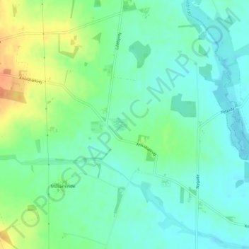
Name: Solsø topographic map, elevation, terrain.
Location: Solsø, Ringkøbing-Skjern Kommune, Jutland central, Danemark (56.12841 8.61420 56.12868 8.61466)
Average elevation: 45 m
Minimum elevation: 32 m
Maximum elevation: 71 m
Make a donation
Other topographic maps
Click on a map to view its topography, its elevation and its terrain.
Make a donation
Make a donation
Møllehøj
Møllehøj est le point culminant naturel du Danemark (hors Groenland et îles Féroé) et s'élève à 170,86 mètres d'altitude. Situé dans la partie centrale du Jutland oriental, il domine les collines d'Ejerbjerge dans la commune de Skanderborg, tout près de Ejer Bavnehøj.
Average elevation: 131 m
Yding Skovhøj
Le Yding Skovhøj est le point culminant du Danemark (hors Groenland et îles Féroé), avec une altitude de 172,54 mètres. Il se trouve dans la commune de Skanderborg, dans le Jutland-Central.
Average elevation: 128 m
Make a donation