
Thank you for supporting this site ❤️
Make a donation
Make a donation
Hou topographic map
Click on the map to display elevation.
Thank you for supporting this site ❤️
Make a donation
Make a donation
About this map
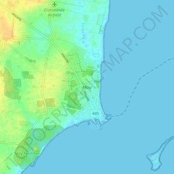
Name: Hou topographic map, elevation, terrain.
Location: Hou, Odder Kommune, Jutland central, Danemark (55.89907 10.23112 55.93907 10.27112)
Average elevation: 5 m
Minimum elevation: -1 m
Maximum elevation: 24 m
Thank you for supporting this site ❤️
Make a donation
Make a donation
Other topographic maps
Click on a map to view its topography, its elevation and its terrain.