
Make a donation
England topographic map
Click on the map to display elevation.
Make a donation
England
England's topography is characterized by a diverse landscape that transitions from low-lying plains to rugged uplands. In the north and west, the terrain is dominated by mountain ranges such as the Pennines, often referred to as the "backbone of England," and the Lake District, which includes Scafell Pike, the country's highest peak at 978 meters (3,210 feet). These areas feature steep slopes, deep valleys, and numerous lakes, offering dramatic vistas and varied ecosystems. In contrast, the southern and eastern regions are marked by rolling hills, fertile plains, and expansive lowlands like the Fens, resulting from ancient glacial activity. The coastline is equally varied, with the white chalk cliffs of Dover in the southeast, the rugged cliffs of Cornwall in the southwest, and the sandy beaches of East Anglia in the east. This varied topography not only defines England's natural beauty but also influences its climate, agriculture, and human settlement patterns.
Make a donation
About this map
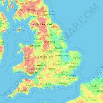
Name: England topographic map, elevation, terrain.
Location: England, United Kingdom (49.67400 -6.70475 55.91700 2.09191)
Average elevation: 55 m
Minimum elevation: -3 m
Maximum elevation: 966 m
Make a donation
Other topographic maps
Click on a map to view its topography, its elevation and its terrain.
United Kingdom
Scotland accounts for just under a third (32 per cent) of the total area of the UK, covering 78,772 square kilometres (30,410 sq mi). This includes nearly eight hundred islands, predominantly west and north of the mainland; notably the Hebrides, Orkney Islands and Shetland Islands. Scotland is the most…
Average elevation: 79 m
Edinburgh
United Kingdom > Scotland > Edinburgh
Some have called Edinburgh the Athens of the North for a variety of reasons. The earliest comparison between the two cities showed that they had a similar topography, with the Castle Rock of Edinburgh performing a similar role to the Athenian Acropolis. Both of them had flatter, fertile agricultural land…
Average elevation: 104 m
Glasgow
United Kingdom > Scotland > Glasgow City
Glasgow itself was reputed to have been founded by the Christian missionary Saint Mungo in the 6th century. He established a church on the Molendinar Burn, where the present Glasgow Cathedral stands, and in the following years Glasgow became a religious centre. Glasgow grew over the following centuries. The…
Average elevation: 128 m
Make a donation
Cambridge
United Kingdom > England > Cambridge
The city, like most of the UK, has a maritime climate highly influenced by the Gulf Stream. Located in the driest region of Britain, Cambridge's rainfall averages around 570 mm (22.44 in) per year, around half the national average, with some years occasionally falling into the semi-arid (under 500 mm (19.69…
Average elevation: 18 m
Scottish Highlands
United Kingdom > Scotland > Highland
The entire region was covered by ice sheets during the Pleistocene ice ages, save perhaps for a few nunataks. The complex geomorphology includes incised valleys and lochs carved by the action of mountain streams and ice, and a topography of irregularly distributed mountains whose summits have similar heights…
Average elevation: 907 m
Make a donation
Croydon
United Kingdom > England > Greater London
Several apartment developments, for instance Altitude 25 (completed 2010), have been built in recent years, and several more are being built or planned. The construction of Saffron Square, which includes a 43-storey tower, began on Wellesley Road in 2011 and was completed in 2016. Other developments with…
Average elevation: 70 m
Make a donation
Make a donation
Make a donation
Romford
United Kingdom > England > Greater London
The town centre is about 50 feet (15 m) above sea level on a gravel terrace rising from the River Thames. The north of the town has developed on London Clay and is situated as much as 150 ft (46 m) above sea level. A continuous gentle rise in the eastern suburbs towards Gidea Park and Harold Wood peaks around…
Average elevation: 29 m
Make a donation
Make a donation
Castle Donington
United Kingdom > England > North West Leicestershire > Castle Donington
Average elevation: 62 m
Make a donation
Swansea
United Kingdom > Wales > Swansea
Much of Swansea is hilly with the main area of upland being located in the council ward of Mawr. Areas up to 185 metres (607 ft) in elevation range across the central section: Kilvey Hill, Townhill and Llwynmawr separate the centre of Swansea from its northern suburbs. Cefn Bryn, a ridge of high land, is the…
Average elevation: 73 m
Make a donation
Make a donation
Bebington
Bebington is on the eastern side of the Wirral Peninsula, approximately 10 km (6.2 mi) south-south-east of the Irish Sea at New Brighton, about 7.5 km (4.7 mi) east-north-east of the Dee Estuary at Gayton and less than 2 km (1.2 mi) west-north-west of the River Mersey at New Ferry. The area is situated at an…
Average elevation: 28 m
Make a donation
Cairn Gorm
United Kingdom > Scotland > Highland
Cairn Gorm (Scottish Gaelic: An Càrn Gorm) is a mountain in the Scottish Highlands. It is part of the Cairngorms range and wider Grampian Mountains. With a summit elevation of 1,244.8 m (4,084 ft) above sea level, Cairn Gorm is classed as a Munro and is the sixth-highest mountain in the British Isles. The…
Average elevation: 989 m
Walton Summit
United Kingdom > England > Lancashire > South Ribble > Bamber Bridge
Average elevation: 67 m
Make a donation
Leeds
Lying in the eastern foothills of the Pennines, there is a significant variation in elevation within the city's built-up area. The district ranges from 1,115 feet (340 m) in the far west on the slopes of Ilkley Moor to about 33 feet (10 m) where the rivers Aire and Wharfe cross the eastern boundary. Land rises…
Average elevation: 94 m
Make a donation
Winter Hill
United Kingdom > England > Blackburn with Darwen > Tockholes
Paths to the summit lead from Belmont (in Blackburn with Darwen), Rivington (in Chorley borough), and Horwich and Blackrod (in Bolton borough). The summit can also be reached via a short walk from the top of a road pass 1+1⁄4 miles (2 km) west of Belmont. The hill is a prominent feature on the skyline for…
Average elevation: 205 m
Napton on the Hill
United Kingdom > England > Warwickshire > Stratford-on-Avon
Average elevation: 113 m
Snowdon
United Kingdom > Wales > Gwynedd
Snowdon (/ˈsnoʊdən/) or Yr Wyddfa (pronounced [ər ˈʊɨ̞̯ðva] (listen)), is the highest mountain in Wales, at an elevation of 1,085 metres (3,560 ft) above sea level, and the highest point in the British Isles outside the Scottish Highlands. It is located in Snowdonia National Park (Parc Cenedlaethol…
Average elevation: 692 m
Make a donation
Make a donation
West Byfleet
United Kingdom > England > Surrey > Woking
The surface undulates gently from the west to the east, where West Byfleet's land is drained in the parish of Byfleet itself by the River Wey. Soil ranges from sandy acidic soil in the west to more alluvial soil in the east, underlain by a mixture of gravel and clay. Elevations range from 18m Above Ordnance…
Average elevation: 26 m
Crowborough
United Kingdom > England > Wealden > Crowborough
In the late 19th century Crowborough was promoted as a health resort based on its high elevation, the rolling hills and surrounding forest. Estate Agents even called it "Scotland in Sussex". The town's golf course opened in 1895, followed by a fire station and hospital in 1900.
Average elevation: 125 m
Make a donation
Weston Park
United Kingdom > England > Staffordshire > South Staffordshire > Weston under Lizard
Average elevation: 113 m
Make a donation
Ben Nevis
United Kingdom > Scotland > Highland
Ben Nevis has a highland (alpine) maritime (oceanic) polar climate (ET climate in the Köppen classification). Ben Nevis's elevation, maritime location and topography frequently lead to cool and cloudy weather conditions, which can pose a danger to ill-equipped walkers. According to the observations carried…
Average elevation: 912 m
Make a donation
Make a donation
Make a donation
Make a donation
Weston-super-Mare
United Kingdom > England > North Somerset > Weston-super-Mare
Average elevation: 13 m
Make a donation
Make a donation
Ely
United Kingdom > England > Ely
For over 800 years the cathedral and its associated buildings—built on an elevation 68 feet (21 m) above the nearby fens—have visually influenced the city and its surrounding area. Geographer John Jones, writing in 1924, reports that "from the roof of King's Chapel in Cambridge, on a clear day, Ely can be…
Average elevation: 13 m
Make a donation
Swindon
United Kingdom > England > Swindon
Swindon has an oceanic climate (Cfb in the Köppen climate classification), like the vast majority of the British Isles, with cool winters and warm summers. The nearest official weather station is RAF Lyneham, about 10 miles (16 km) west southwest of Swindon town centre. The weather station's elevation is 145…
Average elevation: 108 m
Dundee
United Kingdom > Scotland > Dundee City
Dundee sits on the north bank of the Firth of Tay on the eastern, North Sea Coast of Scotland. The city lies 36.1 miles (58 km) NNE of Edinburgh and 360.6 miles (580 km) NNW of London. The built-up area occupies a roughly rectangular shape 8.3 miles (13 km) long by 2.5 miles (4 km) wide, aligned in an east to…
Average elevation: 82 m
Make a donation