
Leeds topographic map
Click on the map to display elevation.
Leeds
Leeds is located 169 miles (272 km) north-northwest of London, on the valley of the River Aire in the eastern foothills of the Pennines. The city centre lies in a narrow section of the Aire Valley at about 206 feet (63 m) above sea level; while the district ranges from 1,115 feet (340 m) in the far west on the slopes of Ilkley Moor to about 33 feet (10 m) where the rivers Aire and Wharfe cross the eastern boundary. There are also significant variations in elevation within the city itself. For example, land rises to 198 m (650 ft) in Cookridge, just 6 miles (9.7 km) from the city centre. The centre of Leeds is part of a continuously built-up area extending to Pudsey, Bramley, Horsforth, Alwoodley, Seacroft, Middleton and Morley.
About this map
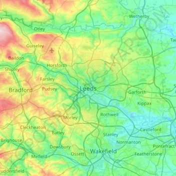
Name: Leeds topographic map, elevation, terrain.
Average elevation: 94 m
Minimum elevation: 7 m
Maximum elevation: 389 m