
Make a donation
Ben Nevis topographic map
Click on the map to display elevation.
Make a donation
Ben Nevis
Ben Nevis has a highland (alpine) maritime (oceanic) polar climate (ET climate in the Köppen classification). Ben Nevis's elevation, maritime location and topography frequently lead to cool and cloudy weather conditions, which can pose a danger to ill-equipped walkers. According to the observations carried out at the summit observatory from 1883 to 1904, fog was present on the summit for almost 80% of the time between November and January, and 55% of the time in May and June. The average winter temperature was around −5 °C (23 °F), and the mean monthly temperature for the year was −0.5 °C (31.1 °F). In an average year the summit sees 261 gales, and receives 4,350 millimetres (171 in) of rainfall, compared to only 2,050 millimetres (81 in) in nearby Fort William, 840 millimetres (33 in) in Inverness and 580 millimetres (23 in) in London. Rainfall on Ben Nevis is about twice as high in the winter as it is in the spring and summer. Snow can be found on the mountain almost all year round, particularly in the gullies of the north face – with the higher reaches of Observatory Gully holding snow until September most years and sometimes until the new snows of the following season.
Make a donation
About this map
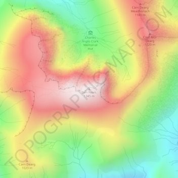
Name: Ben Nevis topographic map, elevation, terrain.
Location: Ben Nevis, Highland, Scotland, United Kingdom (56.79681 -5.00358 56.79691 -5.00348)
Average elevation: 912 m
Minimum elevation: 474 m
Maximum elevation: 1,338 m
Make a donation
Other topographic maps
Click on a map to view its topography, its elevation and its terrain.
Loch Morar
United Kingdom > Scotland > Highland > Morar
Loch Morar (Scottish Gaelic: Loch Mòrair) is a freshwater loch in Lochaber, Highland, Scotland. It is the fifth-largest loch by surface area in Scotland, at 26.7 km2 (10.3 sq mi), and the deepest freshwater body in the British Isles with a maximum depth of 310 m (1,017 ft). The loch was created by glacial…
Average elevation: 118 m
Skye
United Kingdom > Scotland > Highland
Beyond Loch Snizort to the west of Trotternish is the Waternish peninsula, which ends in Ardmore Point's double rock arch. Duirinish peninsula is separated from Waternish by Loch Dunvegan, which contains the island of Isay. It is ringed by sea cliffs that reach 296 metres (971 feet) on the west at Waterstein…
Average elevation: 63 m
Make a donation
Make a donation
Make a donation
Make a donation
Isle of Rum
United Kingdom > Scotland > Highland > Kinloch
The island's relief is spectacular, a 19th-century commentator remarking that "the interior is one heap of rude mountains, scarcely possessing an acre of level land". This combination of geology and topography make for less than ideal agricultural conditions, and it is doubtful that more than one tenth of the…
Average elevation: 118 m
Make a donation
Culloden Battlefield
United Kingdom > Scotland > Highland > Newlands of Culloden > Leanach
Since 2001, the site of the battle has undergone topographic, geophysical and metal detector surveys in addition to archaeological excavations. Interesting finds have been made in the areas on which the fiercest fighting occurred on the government left wing, particularly where Barrell's and Dejean's regiments…
Average elevation: 141 m
Make a donation
Make a donation
Loch Affric
United Kingdom > Scotland > Highland
A number of smaller lochs surround Loch Affric. At the southwestern end sits Loch Coulavie located at the base An Tudair Beag and a slightly higher elevation. Also, at the southwestern end, the river Affric flows into the tiny loch of Loch na Camaig. At the northeastern side, Loch Pollan Fearna drains into…
Average elevation: 477 m
Make a donation
Make a donation
Make a donation
Make a donation
Make a donation
Make a donation
Dunvegan Castle
United Kingdom > Scotland > Highland > Dunvegan > Totachocaire
Average elevation: 41 m
Make a donation
Make a donation
Ardnamurchan
United Kingdom > Scotland > Highland
The north western corner of Ardnamurchan consists of a lopolith (previously interpreted as a ring dyke) that has been exposed at the surface. Evidence for such a structure can be identified from the phenocrysts in the rock exposures around the area of interest which show plagioclase crystals aligned towards…
Average elevation: 73 m
Make a donation
Make a donation
Make a donation
Invergarry Castle
United Kingdom > Scotland > Highland > Invergarry
The survey drawing shows a plan and elevations of the castle, called the 'Castle of Glangary' on the drawing. The drawing may appear misleading, as more than one facade is joined together, but by cross-referencing the lettering on the plan to the elevations the appearance can be judged.
Average elevation: 150 m
Make a donation
Make a donation
Beinn Eighe
United Kingdom > Scotland > Highland
Beinn Eighe (Scottish Gaelic for 'file mountain') is a mountain massif in the Torridon area of Wester Ross in the Northwest Highlands of Scotland. Lying south of Loch Maree, it forms a long ridge with many spurs and summits, two of which are classified as Munros: Ruadh-stac Mòr at 1,010 m (3,314 ft) and…
Average elevation: 633 m
Make a donation
Make a donation
Make a donation
Make a donation
Make a donation