
Thank you for supporting this site ❤️
Make a donation
Make a donation
Lerik topographic map
Click on the map to display elevation.
Thank you for supporting this site ❤️
Make a donation
Make a donation
About this map
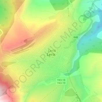
Name: Lerik topographic map, elevation, terrain.
Location: Lerik, Lerik District, Lankaran-Astara, 7384, Azerbaijan (38.76505 48.39852 38.78736 48.42897)
Average elevation: 1,100 m
Minimum elevation: 867 m
Maximum elevation: 1,383 m
Thank you for supporting this site ❤️
Make a donation
Make a donation
Other topographic maps
Click on a map to view its topography, its elevation and its terrain.