
Make a donation
Benton County topographic map
Click on the map to display elevation.
Make a donation
About this map
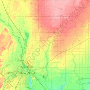
Name: Benton County topographic map, elevation, terrain.
Location: Benton County, Minnesota, United States (45.55907 -94.35320 45.82417 -93.75909)
Average elevation: 340 m
Minimum elevation: 289 m
Maximum elevation: 407 m
Make a donation
Other topographic maps
Click on a map to view its topography, its elevation and its terrain.
Saint Paul
United States > Minnesota > Ramsey County > Saint Paul
The year 1858 saw more than 1,000 steamboats service Saint Paul, making it a gateway for settlers to the Minnesota frontier or Dakota Territory. Geography was a primary reason the city became a transportation hub. The location was the last good point to land riverboats coming upriver due to the river valley's…
Average elevation: 273 m
Make a donation
Minneapolis
United States > Minnesota > Hennepin County > Minneapolis
A 1959 report by the U.S. Soil Conservation Service listed Minneapolis's elevation as 830 feet (250 m). The city's lowest elevation of 687 feet (209 m) above sea level is near where Minnehaha Creek meets the Mississippi River. Sources disagree on the exact location and elevation of the city's highest point,…
Average elevation: 271 m
Make a donation
Make a donation
Chimney Rock Scenic and Natural Area
United States > Minnesota > Dakota County
Average elevation: 269 m
Make a donation
Devils Lake
United States > Minnesota > Pine County > Pine City > Pine Terrace Mobile Home Park
Average elevation: 295 m
Make a donation
Make a donation
Make a donation
Make a donation
Minnesota Valley State Recreation Area
United States > Minnesota > Scott County
Average elevation: 224 m
Make a donation
Make a donation
Make a donation
Make a donation
Make a donation
Make a donation
Make a donation
Make a donation
Make a donation
Minnehaha Falls
United States > Minnesota > Hennepin County > Minneapolis
Fortunately for the generations to come, in 1883 the state legislature created the Minneapolis Board of Park Commissioners. The board began by acquiring park land near today's downtown Minneapolis. Their choice to hire noted landscape architect Horace Cleveland was fortunate. Cleveland was hired by the Board…
Average elevation: 249 m
Make a donation
Wagon Wheel Mobile Home Park
United States > Minnesota > Itasca County > Grand Rapids
Average elevation: 410 m
Make a donation
Make a donation
Make a donation
Prior Lake
United States > Minnesota > Scott County > Prior Lake > Prior Lake
The eastern portion of Spring Lake along Scott County Road 12 is also located within the City of Prior Lake. Spring Lake, with 290 acres, but being a few minutes further out from the metro area offers similar recreational opportunities as Upper Prior Lake with a more rural character and less traffic. Spring…
Average elevation: 289 m
Burnsville
United States > Minnesota > Dakota County > Burnsville > Burnsville
Average elevation: 275 m
Albert Lea
United States > Minnesota > Freeborn County > Albert Lea > Albert Lea
Average elevation: 380 m
Make a donation
South Haven
United States > Minnesota > Wright County > South Haven > South Haven
Average elevation: 331 m
Farmington
United States > Minnesota > Dakota County > Farmington > Farmington
Average elevation: 280 m
Make a donation
Bloomington
United States > Minnesota > Hennepin County > Bloomington > Bloomington
Average elevation: 253 m
Baudette
United States > Minnesota > Lake of the Woods County > Baudette > Baudette
Average elevation: 331 m
Fergus Falls
United States > Minnesota > Otter Tail County > Fergus Falls > Fergus Falls
Average elevation: 375 m
Chain Lake
United States > Minnesota > Chisago County > North Branch > Harris
Average elevation: 281 m
Make a donation
Make a donation