
Persian Gulf topographic map
Interactive map
Click on the map to display elevation.
About this map
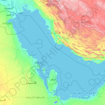
Name: Persian Gulf topographic map, elevation, terrain.
Location: Persian Gulf, Iran (23.95663 47.70057 30.51955 55.79921)
Average elevation: 432 m
Minimum elevation: -15 m
Maximum elevation: 3,970 m
Other topographic maps
Click on a map to view its topography, its elevation and its terrain.
Qarabag
Iran > West Azerbaijan Province > Urumia County > دهستان انزل شمالی
Average elevation: 1,527 m
Malham
Iran > West Azerbaijan Province > Maku County > دهستان چایباسارشمالی
Average elevation: 1,277 m
Alamut Castle
Iran > Qazvin Province > Qazvin County > دهستان الموت بالا > Gazor khan
Average elevation: 2,031 m
Tiss Beach Resort
Iran > Sistan and Baluchestan Province > Chabahar County > دهستان وشنام دری > Tis
Average elevation: 13 m
Kakhk
Iran > Razavi Khorasan > Gonabad County > دهستان کاخک
The city is classified as having a steppe climate with medium latitude at an altitude of 1483.26 meters above sea level. The annual temperature of the region is 17.42 degrees Celsius and 1.01% lower than the average temperature of Iran. Kakhk normally receives about 26.86 mm of rain and has 51.34 rainy days…
Average elevation: 1,634 m
Baba Jan, East Azerbaijan
Iran > East Azerbaijan Province > Ahar County > دهستان قشلاق
Average elevation: 1,752 m
Kelardasht
Iran > Mazandaran Province > Kelardasht County > دهستان کلاردشت غربی
Average elevation: 1,473 m
Dena
Iran > Kohgiluye and Buyer Ahmad Province > Dena County > دهستان دنا
Mount Dena has more than 40 peaks higher than 4,000 metres (13,000 feet). With an elevation of 4,409 metres above sea level, Qash-Mastan is the highest peak in the Dena Range and in the Zagros Mountains in general. Another known peak in this range is Hose-Daal close to the city of Sisakht, 30 km (19 mi) to the…
Average elevation: 3,896 m
Tabriz
Iran > East Azerbaijan Province > Tabriz County > Tabriz
Tabriz (Persian: تبریز (listen); Azerbaijani: تبریز) is the most populated city in northwestern Iran, one of the historical capitals of Iran and the present capital of East Azerbaijan province. It is the fifth most populous city in Iran. Located in the Quru River valley, in Iran's historic…
Average elevation: 1,594 m
Nasirabad
Iran > Lorestan Province > Khorramabad County > دهستان کاکاشرف > Cham Bagh
Average elevation: 1,528 m
Telk Abad
Iran > Isfahan Province > Ardestan County > دهستان ریگستان > Telk Abad
Average elevation: 989 m
Masjed Soleyman
Iran > Khuzestan Province > Masjedsoleyman County > دهستان جهانگیری شمالی > Masjed Soleyman
Average elevation: 327 m