
Thank you for supporting this site ❤️
Make a donation
Make a donation
Kakhk topographic map
Click on the map to display elevation.
Thank you for supporting this site ❤️
Make a donation
Make a donation
Kakhk
The city is classified as having a steppe climate with medium latitude at an altitude of 1483.26 meters above sea level. The annual temperature of the region is 17.42 degrees Celsius and 1.01% lower than the average temperature of Iran. Kakhk normally receives about 26.86 mm of rain and has 51.34 rainy days annually.
Thank you for supporting this site ❤️
Make a donation
Make a donation
About this map
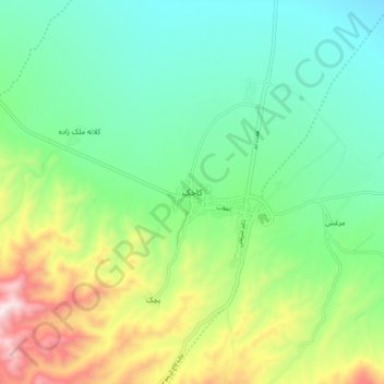
Name: Kakhk topographic map, elevation, terrain.
Average elevation: 1,634 m
Minimum elevation: 1,404 m
Maximum elevation: 2,149 m
Thank you for supporting this site ❤️
Make a donation
Make a donation