
Make a donation
Persian Gulf topographic map
Click on the map to display elevation.
Make a donation
About this map
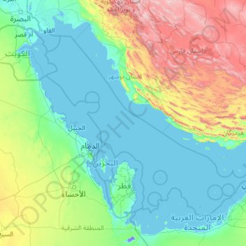
Name: Persian Gulf topographic map, elevation, terrain.
Location: Persian Gulf, Iran (23.95663 47.70057 30.51955 55.79921)
Average elevation: 432 m
Minimum elevation: -15 m
Maximum elevation: 3,970 m
Make a donation
Other topographic maps
Click on a map to view its topography, its elevation and its terrain.
Qarabag
Iran > West Azerbaijan Province > Urumia County > دهستان انزل شمالی
Average elevation: 1,527 m
Malham
Iran > West Azerbaijan Province > Maku County > دهستان چایباسارشمالی
Average elevation: 1,277 m
Make a donation
Make a donation
Alamut Castle
Iran > Qazvin Province > Qazvin County > دهستان الموت بالا > Gazor khan
Average elevation: 2,031 m
Kakhk
Iran > Razavi Khorasan > Gonabad County > دهستان کاخک
The city is classified as having a steppe climate with medium latitude at an altitude of 1483.26 meters above sea level. The annual temperature of the region is 17.42 degrees Celsius and 1.01% lower than the average temperature of Iran. Kakhk normally receives about 26.86 mm of rain and has 51.34 rainy days…
Average elevation: 1,634 m
Make a donation
Tiss Beach Resort
Iran > Sistan and Baluchestan Province > Chabahar County > دهستان وشنام دری > Tis
Average elevation: 13 m
Kelardasht
Iran > Mazandaran Province > Kelardasht County > دهستان کلاردشت غربی
Average elevation: 1,473 m
Make a donation
Baba Jan, East Azerbaijan
Iran > East Azerbaijan Province > Ahar County > دهستان قشلاق
Average elevation: 1,752 m
Make a donation
Masjed Soleyman
Iran > Khuzestan Province > Masjedsoleyman County > دهستان جهانگیری شمالی > Masjed Soleyman
Average elevation: 327 m
Make a donation
Make a donation
Telk Abad
Iran > Isfahan Province > Ardestan County > دهستان ریگستان > Telk Abad
Average elevation: 989 m
Make a donation
Make a donation
Make a donation
Make a donation